  • English
  • Español
  • Français

United
Nations


Office for Outer Space Affairs
UN-SPIDER Knowledge Portal

  • Inicio
  • Sobre nosotros
    • Sobre ONU-SPIDER
    • Acerca de UNOOSA
    • Publicaciones
    • Ofertas de trabajo
    • Conozca el Equipo
    • Contacto
  • Aplicación Espacial
    • Guías Tecnológicas
    • Mecanismos de Emergencia
    • Mecanismos de Recuperación
    • Red Internacional de Alerta de Asteroides
    • Grupo Asesor para la Planificación de Misiones Espaciales
    • Iniciativa Internacional sobre Meteorología Espacial
    • Tecnologías Espaciales en la ONU
    • Historias de Usuarios
  • Enlaces y Recursos
    • Aplicación de datos del mes
      • Disaster Recovery
    • Fuentes de Datos
    • SIG y Software de Percepción Remota
    • Recursos de capacitación en línea
    • Instituciones
  • Riesgos y Desastres
    • Gestión del Riesgo de Desastres
    • Alerta temprana
    • Gestión de Desastres y Emergencias
    • Amenazas Naturales
    • El Proceso de la Reducción de Desastres Post-2015
    • La ONU y la Gestión del Riesgo de Desastres
    • La ONU y Alerta Temprana
    • La ONU y la Gestión de Desastres
  • Asesoría
    • Misiones de Asesoría
    • Apoyo en caso de Emergencia
    • Asesoría Virtual
    • Prácticas Recomendadas
    • Actividades de Entrenamiento
    • Usos Prácticos
  • Redes
    • Oficinas Regionales de Apoyo
    • GP-STAR
    • IN-MHEWS
    • IWG-SEM
  • Proyectos
    • SPEAR
    • FOSAT-S
    • EvIDENz
    • Flood GUIDE
  • Noticias y Eventos
    • Noticias
    • Eventos
    • Eventos pasados

Breadcrumb

  • Home
  • Top of The Atmosphere (TOA)
  • Top of the Atmosphere (TOA)

Top of the Atmosphere (TOA)

Digital Number (DN)

Digital Number (DN) is the generic term used for pixel values. These values correlate with the energy that is observed and measured at the sensor. Although the DNs are related to the surface reflectance values, they are not the same. Depending on the purpose of the study, comparing DNs acquired by a satellite, without correcting for atmospheric effects, can lead to problems - even if the Landsat DNs have been calibrated and processed.

Radiance, Reflectance, and Top of Atmosphere (TOA)

Radiance is directly measured by remote sensing instruments. Radiance includes the radiation reflected from the surface, in addition to the radiation that bounces in from neighboring pixels, and the radiation reflected from clouds. Radiance is dependent on not only the illumination (both its intensity and direction), but the orientation and position of the target also. In other words, the path of light through the atmosphere can change as the light travels down to the earth through the atmosphere, suffering wavelength-dependent scattering. The light then diffusively reflects off of the Earth's surface (Figure 1), travelling back up through the Earth's atmosphere, enduring further scattering effects as it does so. Some of these factors can be corrected by using Top of Atmosphere (TOA) reflectance values, instead of DNs.

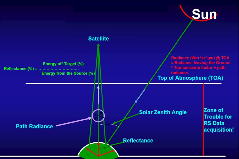
Figure 1. Illustration of radiance, reflectance, and TOA. Source: United States geological Survey (USGS).

For more information:

  • The tutorial developed by USGS shows more information about atmospheric physics and corrections. Click here to access it.
  • More about digital number, radiance and reflectance, click here.


Video explaining about digital number, radiance, and reflectance

Footer menu

  • Contact
  • Terms of Use

User account menu

  • Log in