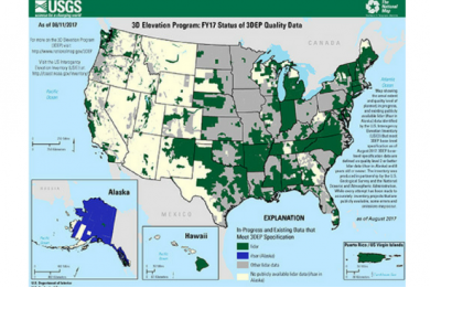
When natural hazards, such as hurricanes and rainstorms, approach a specific area, high-resolution elevation mapping data can help assess and mitigate likely damage. In order to support geospatial data collection, the United States Geological Survey (USGS) launched the 3D Elevation Program (3DEP) to systematically collect enhanced elevation data in the form of high-quality light detection and ranging (LiDAR) data over coextensive United States, Hawaii, and U.S. territories.
While flooding is one the most common and costly disasters, it can also change weather patterns and influence other factors. Through 3DEP, agencies and organizations can ensure they are prepared for natural disasters. The programme has proven to be effective, for instance one the most recent application is North Carolina, being the first state to map its entire area with resolution LiDAR. By collecting and analyzing elevation data, the state uses LiDAR data to model hazards, identify vulnerable areas and and execute impact assessments at the time of flooding. Disaster preparedness and planning is efficient as a result of relevant information on flood warning systems. As part of the efficiency of the collected data, North Carolina is capable of calculate anticipated flooding, displayed on the its Flood Inundation Mapping and Alert Network, which empowers officials to advise precise guidance on evacuations and assist in emergency response.
The Federal Emergency Management Agency (FEMA) expects that a national enhanced elevation program could reduce the amount of time needed to update its flood maps. The enhanced data could provide significant benefits to the communities and citizens that are customers of the National Flood Insurance Program. For example, updated information could be delivered to affected communities and homeowners more quickly.
Flood warning systems play an important role in minimizing effects by helping to evacuate people from the probable affected areas during flood times. With LiDAR data agencies are prepared to have a bigger scope of flood travel times, which helps the evacuation process from the probable affected areas. The North Carolina Floodplain Mapping Program highlights how the organization is using LiDAR data to support elevation-enabled flood inundation mapping in advance of major storms, and create highly accurate models.
Independent of the agency using the elevation data, meaning 3DEP and LiDAR, it becomes essential information considering is cost saving to build environments, and infrastructure identification and management. Allowing the areas affected to avoid losses related to hazards, helps to provide a quick and efficient response to a variety of scenarios.

