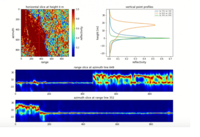
A new online SAR tutorial offered by EO College, a joint education initiative for Radar Remote Sensing by the German Aerospace Center (DLR) and Friedrich-Schiller University Jena, provides insights into 3D Synthethic Aparture Radar (SAR) analysis. The value added of 3D SAR analysis lies in the combination of images taken from different viewing angles and the possibility to combine these images to measure heights with better accuracy.
In the online course, participants learn to develop a static plot that can be adjusted depending on the horizontal slice reflectivity and the vertical profile. Together with the possibility to obtain charts from different horizontal slices at different inversion heights and the possibility to visualize different vertical profiles on top of each other, the online course demonstrates how to transfer the data to geocoordinates for a complete visualization.
The tutorial uses Python3 and other operating systems that can be easily downloaded following the instructions displayed on Github. The materials available on the EO College website include a theory unit, F-SAR test data for download and related documentation.
Why SAR is relevant for disaster management?
SAR is used in disaster management of floods, cyclones, tsunami inundations and other disasters as it detects different reflectivity levels and it does not depend on good weather conditions or light variations to obtain useful data. The coherence level between the pre-disaster image and the post-disaster image helps to detect the affected areas. With SAR tomography and the coherence level obtained from several images taken from different angles, the precision of the disaster is higher and the possibility to prevent or manage the hazard increases.

