![]()
United
Nations
ICPAC Drought Watch, Flood Hazards and Risks (IGAD)
| Data provided by: | Intergovernmental Authority on Drought and Development (IGAD) |
| Data accessibility: | Exportar mapa, Visualización de datos (ej. web SIG o monitoreo en tiempo real) |
| Link to the data: | |
| Data type: | Datos sobre amenazas específicas |
| Disaster cycle phase: | Gestión des Riesgo por Desastres, Respuesta, Recuperación |
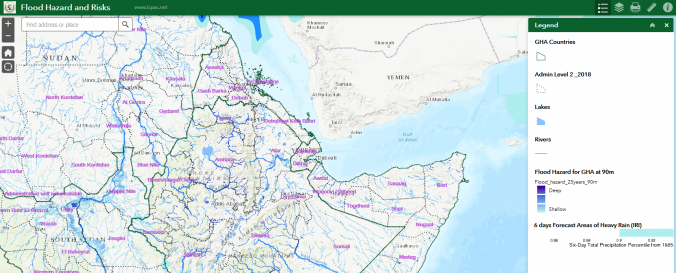
| Space-based Information: | ICPAC drought maps present current rainfall anomaly (Standardized Precipitation Index (SPI)), vegetation anomaly, hydrological condition and rangeland drought monitoring maps. ICPAC Flood Hazard and Risk Maps present flood hazard maps, population estimates, near-real time rainfall 10 day maps from TAMSAT, flood frequency maps for 100 years. Regional focus: Sudan, Ethiopia, Kenya, Tanzania, Somalia, South Sudan. TAMSAT is the acronym for Tropical Application of Meteorology Using Satellite Data and Ground-Based Observations which is a rainfall estimation and quality assessment system providing high-resolution (~4 km) , 10-daily (or monthly) pan-African rainfall estimates. The TAMSAT system is based on two cardinal data sets: 1) Rainfall estimates based on time-lapse analysis of the cloud-top temperature distribution and development observed every 30 minutes (every 15 minutes since July 2006) by thermal infrared (TIR) imagery from aboard the Meteosat satellites of the first and second generation [Grimes et al., 1999; Maidment et al., 2014, 2017, see References]. This retrieval is based on the assumption of a positive linear relationship between the life-time of convective clouds and the amount of rainfall at the surface; it works best (if not exclusively) for convective precipitation. 2) a thoroughly quality-assessed rain gauge data archive for the calibration of the TAMSAT rainfall estimation algorithm spanning years 1983-2012; in addition to that near-real-time rain gauge data available since 2011 are used for operational validation of the TAMSAT rainfall estimates. |
| Satellites and Sensors: | Meteosat-8 (SEVIRI) |
| Spatial coverage: | Africa |
| Spatial resolution: | ~20miles, 30km, 90m Flood Hazard |
| Temporal coverage: | Archivado, Casi en tiempo real |
| Content dates: | 1981-2015, present, Varying by data set |
| Technical Specifications: | |
| Costs: | Gratis |
| Contact: | Contact |
| Restrictions/ Citation of the dataset: |
Provider
![]()