The International Telecommunication Union (ITU) has published a new report about the use and opportunities of ICT and disruptive technologies for disaster risk reduction and management. The publication was announced during the third ITU Global Forum on Emergency Telecommunications, which took place from 6 to 8 March 2019 in Balaclava, Mauritius.
The study finds that technological advancement and innovation are creating new opportunities for enhancing disaster resilience and risk reduction. Developments in disruptive technologies, such as artificial intelligence, the Internet of Things (IoT) and Big Data, and innovations in robotics and drone technology, among other areas, are transforming disaster risk reduction and management. Disruptive technologies can spread critical information more quickly, improve understanding of the causes of disasters, enhance early warning systems, assess damage in new ways and add to the knowledge base of the social behaviours and economic impacts after a crisis strikes.
The term of disruptive technology was first introduced more than two decades ago with reference to new technologies having an impact on incumbent businesses with scope for major disruption. Today, the term has widened by including the innovative application of new technologies across a range of domains, including disaster risk reduction and management.
The rapid growth of supporting digital infrastructure and devices, such as wireless broadband networks, smartphones and cloud computing, has created the foundation for the application of disruptive technologies for disaster management.
The spread and availability of these technologies vary among developed and developing nations and among high and low-income regions, and this digital divide influences their suitability for different disaster management scenarios.
Applications of disruptive technologies to disaster management vary in pace, scope and impact. While the use of drones and IoT is increasing, older technologies, such as satellite imagery and seismometers, are still the most important methods for detecting, monitoring and accessing disasters, and text messaging has the widest reach for communicating with the public.
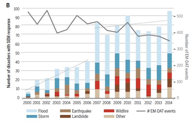
Regarding space technology, the document highlights that satellite-based emergency mapping (SEM) has improved both in quality and response. For instance, new synthetic radar apertures can see through storm clouds, and coordination between the satellite and relief communities has improved.

The document also shows practical examples of the application of emerging technologies and their current and potential impact for managing and reducing the impact of disasters. It includes best practices from a range of countries including Vanuatu, India, Mexico, Japan and Colombia.
Crowdsourcing
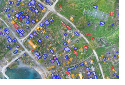
The public is increasingly using digital technologies to support disaster management. This includes crowdsourcing, used to add vital details to maps of disaster areas. This enhances satellite imagery by providing greater granularity, making relief efforts more effective and targeted. It is also quicker and cheaper, especially since the crowd often does this on a volunteer basis compared to traditional methods.
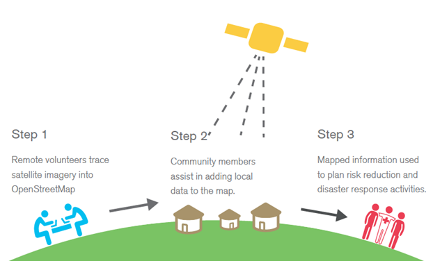
For instance, Missing Maps is a project launched in 2014 and spearheaded by the American Red Cross, the British Red Cross, Médecins Sans Frontières–UK and the Humanitarian OpenStreetMap Team. It uses volunteers to add information to maps in order to better serve those affected by a crisis and get assistance to them more rapidly. In the first stage, volunteers edit satellite imagery to add details.
More than 2500 people have provided assistance, making 3.7 million edits and locating 4.5 million people on the map. The second stage involves working with local communities to add details about roads and buildings. The last stage includes data validation and inputting project-specific information to generate maps for different disaster programmes.
Key Recommendations
The study identifies several recommendations for governments, relief and assistance agencies and the private sector, mostly to help them maximize benefits offered by disruptive technologies.
Systematization and standardization are needed to improve the application of technology interventions
Reach of digital technologies must be factored into disaster management strategies.
A global repository featuring information on how digital technologies are being applied for disaster management would raise awareness and understanding
Partnerships with the private sector and academia will be critical for understanding and applying digital technologies for disaster prediction, detection, response and relief
Training is indispensable for the disaster community to understand how to properly and responsibly deploy new and emerging digital technologies in crisis settings.


