The National Oceanic and Atmospheric Administration (NOAA) has recently upgraded its Probabilistic Storm Surge (P-Surge) model ahead of 2023 Hurricane Season beginning on June 1. The P-Surge is the primary model for predicting storm surge associated with high-impact weather, such as hurricanes and tropical storms. The version 3.0 advances storm surge modeling and forecasting for the continental United States, Puerto Rico, and the Virgin Islands.
The upgrade features several capabilities that will help forecasters understand the risk of storm surge, such as new forecasts for surge, tide and waves for Puerto Rico and the U.S. Virgin Islands. Forecasters can also now run the model simultaneously for two storms, capability that can help during two landfalling storms impacting the CONUS, or one storm impacting the U.S. and one impacting Puerto Rico and/or the U.S. Virgin Islands. Furthermore, the upgraded model improves calculations of friction over different types of land surfaces, which helps more accurately compute the extent of water inundation along the coast.
The model uses official wind forecasts from NOAA's National Hurricane Center (NHC) as well as NHC's historic 5-year average errors in track, size and intensity of storms to create a collection of roughly 500 to 1,000 representative wind and pressure inputs. Those inputs are fed into NOAA’s Sea, Lake and Overland Surges from Hurricanes (SLOSH) model, which computes water levels and inundation due to storm surge and tide. P-Surge combines the resulting water level outputs from SLOSH with the likelihood of the representative inputs from NHC data to create probabilistic products. This approach provides a range of possible outcomes based on the percent chance of each, and allows NWS forecasters to communicate worst-case scenarios to core partners and the general public.
To read more on the model, click here.
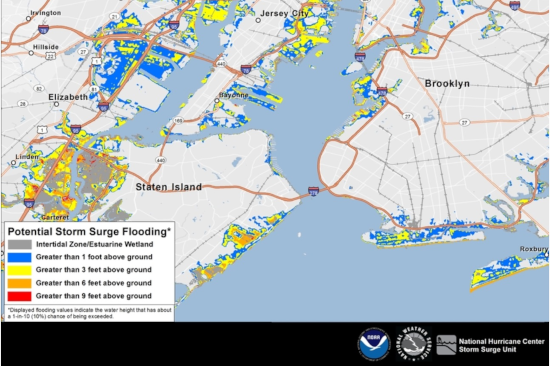
Main image: P-Surge 3.0 map. Illustration of a hypothetical “Hurricane X” on the New York City / Jersey City / Staten Island area. © National Hurricane Center