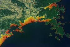
Modeled tsunami zones for affected areas of the Japan earthquake.
The model calculates inundation depths/areas according to a given tsunami wave height .
The model is based on topography only, using SRTM data with a horizontal resolution of approximately 90m.
Inundation zones were calculated for all coasts of the world (which are covered by SRTM data) independent from the actual tsunami probability 3 wave heights are pre-calculated 5m, 10m and 20m.
The inundation zones were calibrated to the Indian Ocean tsunami of 2004. It is accessible through the DVD Globe of Natural Hazards, by Munich Re.
Source:
Modeled Tsunami Zones: Lorenz Dolezalek (Munich RE), 2011
Esri Background: ESRI, I-cubed, USDA FSA, USGS, AEX, GeoEye, Getmapping, Aerogrid, IGP
Lorenz Dolezalek
LDolezalek [at] munichre.com
| Attachment | Tamaño |
|---|---|
| Comparison.jpg (678.57 KB) | 678.57 KB |
| Iwaki_detail.jpg (658.34 KB) | 658.34 KB |
| Miyako_detail.jpg (646.95 KB) | 646.95 KB |
| Sendai_detail_North.jpg (799.51 KB) | 799.51 KB |
| Tone.jpg (546.03 KB) | 546.03 KB |
| Miyako.jpg (486.58 KB) | 486.58 KB |
| Rikuzentakata.jpg (634.14 KB) | 634.14 KB |
| Sendai_detail.jpg (716.02 KB) | 716.02 KB |
| Soma.jpg (716.31 KB) | 716.31 KB |

