Vicente García García, Humberto L. Perotto-Baldivieso, Stephen Hallett
Natural Resources Department, Cranfield University, United Kingdom
Introduction
Frequency and severity of natural disasters are reportedly increasing worldwide, partially due to population increase and increasing concentration of populations in hazard-prone environments (1). Their effects are related to the vulnerability of the affected area and the proximal human population (2). Flooding is one of the most serious and common natural disasters. Flooding statistics show how in the last 20 years there have been more than 2,800 flooding events with over 2,000,000,000 people affected and over 190,000 people killed (Table 1).
| Number of flood events | 2,887 |
| Number of people killed | 195,843 |
| Average number of people killed per year | 6,753 |
| Number of people affected | 2,809,481,489 |
| Average number of people affected per year | 96,878,672 |
Table 1: Flood statistics (1980 – 2008) (3)
Geospatial data can be used to develop analytical modelling, risk mapping and vulnerability area mapping as well as to support and execute emergency response plans. Morover, GIS can serve as a spatial inventory system for coordinating recovery activities (4), (5).
Although GIS and spatial data play an important role in disaster management, data formats and data standards can also prove a limiting factor in the deployment of GIS infrastructure. The number of organizations, agencies and private companies around the world that produce and use spatial data (geospatial data) is continuously increasing; therefore there is a need for GIS interoperability to share geospatial data, services and functionality (6). An effective strategy to achieve the GIS interoperability is by creating a Spatial Data Infrastructure (SDI).
SDI is defined as the combination of technology, policy and institutional arrangements that facilitate the availability and access to spatial data. SDI provides a basis for spatial data discovery, evaluation, and application for users and providers within all levels of the government, the commercial sector, the non-profit sector, the academic sector, and by the public(7). SDI as an information infrastructure can help by providing spatial data and supporting decision-making for disaster management. Designing an SDI model for a disaster management, utilizing important spatial data, non-spatial, semantic data, associated metadata and communication technologies (ICT) in disaster management can improve decision-making and increase the efficiencies and effectiveness of all level of disaster management activities from mitigation to preparedness, response and recovery phases (8).
The use of Web-based platforms for SDI provides the capability of delivering GIS information and functionality to a wide number of users via the Internet. A recent development is the increasing deployment of Free or Open Source GIS tools (FOSS-GIS). In adopting FOSS-GIS, users do not need to have proprietary GIS software installed, thereby reducing software costs and software installation troubles. In applications such as disaster magagement the use of Web-based GIS tools can prove extremely effective. Such a prototype ‘platform’ can comprise components which include a Web server (eg. Apache), as well as the software for publishing spatial data and interactive mapping applications to the Web. Given the wide number of FOSS-GIS server applications and GIS platforms now available, there is a need to assess their feasibility for disaster management applications in areas where data standards can be a limiting factor.
Bolivia is subject to periodical flooding in the tropical lowlands (on the eastern plain, or “Llanura oriental”) and every year there are signigificant losses in livestock and property. Most of the water that floods the “Llanura oriental” originates from the valleys and mountains in the upper reaches of the Amazon watershed. The first two floods to be widely documented using GIS and remote sensing were the flooding events of 2007 and 2008 (9). Data for these events is made publicly available at the Bolivian Natural Resources Digital Center (BNRDC, http://essm.tamu.edu/bolivia). The first SDI with standardized formats for Bolivia was created by the BNRDC in 2004. Data was formatted and prepared to meet scale and projection standards at the national level using the Bolivian legal framework. Since this time, the BNRDC has provided the most comprehensive repository for spatial data at the national level. Data offered by BNDRC includes social (e.g. infrastructure, political boundaries) and natural (e.g. ecosystems, soils, digital elevation models) spatial information and it is made available to the public at no cost. However, data is managed in a GIS-native format and therefore the use may be limited to users with relevant GIS experience.
The idea of developing a prototype for a Web-GIS disaster support system therefore emerged as a means to combine the existing SDI with contemporary Web-GIS developments for the design and implementation of spatially explicit online decision support systems for disaster management. This paper presents the development of an online disaster support system designed to provide key information to end-users and policy makers where a massive flood event is occurring or has occurred. The specific project objectives were firstly to evaluate the applicability of different Web-GIS platforms for the implementation of the disaster support system, and secondly to assess its acceptance among scientists, decision makers, and the general public.
Methodology
Case Study and Data collection
The 2007 and 2008 floods in the Bolivian Llanura oriental were chosen as a suitable case study for the development of a prototype disaster support system, given the extensive data available for these events, and the willingness of the Bolivian Natural Resources Digital User Group to participate in an applicability survey, conducted via an online questionnaire. Data used in this project was provided by BNRDC in ESRI Shapefile format (10). The spatial data available on BNRDC is in a geographic coordinate system WGS84 (decimal degrees latitude, longitude). Data provided was divided into five categories: administrative (departments, provinces, municipalities and department capitals), infrastructure (hospitals, airports, harbours, primary roads, and railways), natural spatial data (rivers, geology, protected areas, and watershed information) and flooding data (2007 and 2008 flooding, potential floods areas and potential draught areas).
Platform selection and platform design
The system platform selected for the disaster support system was based on the choice of the Web client for the Web-GIS. The Web client provides the interface that allows the users to visualize, navigate and analyze the geospatial data via the Web. We selected three Web clients to test the online disaster support system, namely: ‘p.mapper’, ‘OpenLayers’ and ‘Chameleon’ (11). The selection of the Web client was based on the following criteria:
- Free or open source software (FOSS);
- Quality of navigation tools provided;
- Management tool provided for hierarchical layer management;
- Capabilities of query and measurement tools;
- Capabilities for scale management and search functionality;
- Ease of interface customization, plug-ins and functions compatibility;
- Programming languages supported;
- Established community of users and developers;
- Support for the OGC-compliant services, WMS and WFS; and
- Data interoperability (vector, raster, PostGIS).
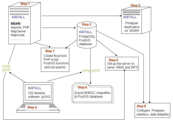
Based on the above criteria, p.mapper was selected as it meets the majority of the requirements, and a prototype tool was developed, a detailed explanation of which is presented in the results section below. The p.mapper server is a MapServer application based on PHP/Mapscript. The freely available MapServer for Windows package (MS4W) was selected, installing the pre-configured Web server environment required to establish a p.mapper application (comprising the Apache Web server, MapServer, PHP, Mapscript, and the Geospatial Data Abstraction Library, or GDAL). Once installed MS4W provides the possibility for updating individual components without affecting or modifying the rest of the installed applications – a concern for managing ongoing support for such an application platform.Once MS4W was established, the object-relational database system PostgreSQL and its extension PostGIS was also installed to provide the underlying data repository for the platform. A key stage then involved the conversion and export of the Bolivian geospatial data, from shapefiles, into the PostGIS database format. Finally the p.mapper application was customized to meet the needs of the prototype (Fig. 1).Detailed information about the development of the Web-GIS platform is provided by (12).

Figure 1: Platform design for the disaster support system prototype.
User group acceptance
The finalized Web-GIS prototype (http://ccmap-dmz.dmz.cranfield.ac.uk/index.phtml) was next presented to the BNRDC user group who were then able to provide feedback via an online questionnaire (12). The questionnaire adopted was divided into 6 sections and totalling 23 questions. The questions were categorised as: general overview; tools; symbology and legend; map; download and print; and conclusions and recommendations, with respondees being invited to complete a questionnaire reflecting their experience of running the prototype. Scoring for each question ranged from 1 (being very poor) to 5 (being excellent). Questionnaire results were analysed and interpreted using boxplots (13).
Results
Platform selection and platform design
The p.mapper tool was selected as a Web client as it was found to address substantially the technical requirements of the prototype. A comparative review between p.mapper and the other comparable FOSS tools Chameleon and OpenLayers is reported in Table 2. Some of the main characteristics that defined the choice for the final selection include:
- Significant number of navigation tools: ease of ability to zoom in, zoom out, select full extent, pan forward and backward, and zoom to selected points;
- Information tools: strength of layer attribute queries;
- Area and distance measurements;
- Bookmarking and selection tools;
- Data export reporting (e.g. pdf file production) and printing tools;
- Hierarchcial layer arrangement and layer visualization;
- Interface customization; and
- Access to open source software.
| Web client | Program. language | Data support | OGC support | Server dependency | Nav. control tools | Layer info tools | Search tools |
|---|---|---|---|---|---|---|---|
| Chameleon | Javascript; PHP | PostGis Web Map Context | WMS | Yes UMN MapServer | good | some problems | good |
| p.mapper | Mapscript; PHP | PostGis Shapefile Tiff ECW | WMS; WFS | Yes UMN MapServer | very good | very good | very good |
| OpenLayers | Javascript | GML, KML, Shapefile | WMS; WFS | No | good | no | no |
Table 2: Technical Characteristics API
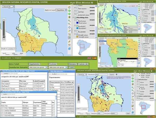
The software selected to implement the Web component was MapServer because the p.mapper application is complementary to MapServer. Map Server was integrated with the installation of the Apache HTTP Server. Once the system was established, it was made publicly available online via Cranfield University’s Web servers (http://ccmap-dmz.dmz.cranfield.ac.uk/index.phtml) (Fig. 2).

Figure 2: Disaster Support System Web-GIS application finalized. The screens portray several snapshots of the flooding management support system in Bolivia.
In this Web-GIS users are able to navigate through the data with the zoom and pan tools, select features, extract information from the features, export data, print the map, analyse and interpret the data, search for attributes and obtain information about the spatial parcels affected by the floods.
User group acceptance
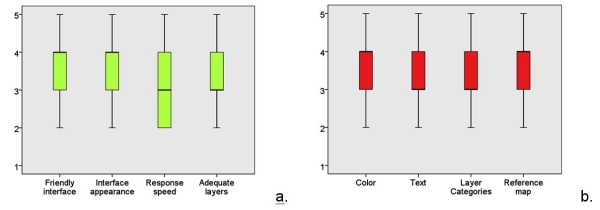
A total of 23 BNRDC users provided feedback via the online questionnaire. The median answer across the questionnaire for all questions was found to be equal or greater than 3, indicating a general positive acceptance of the Web-GIS platform used as a flooding support system. Questions relating to the ease of use of the interface, the speed of use, and the overall appearance had medians equal or greater to 3 with the highest scores given to the graphical interface and general appearance of the user interface (Fig. 3).

Figure 3: User response box plots summarising acceptance questionnaire results for (a) General overview, and (b) Lay out. Note, values in the Y axis represent the degree of acceptance with 1 being very poor and 5 being excellent.
Download and printing capabilities received average scores while most display tools received average to good scores. Map composition capabilities and expectations received good scores. Most users who participated reported themselves as satisfied with the interface and several suggestions were proposed to improve the Web-GIS platform. Overall satisfaction scores indicate that 22 % of the users were not satisfied with the application, 59 % were satisfied and 18% were very satisfied.
Discussion and Conclusions
The selection criteria adopted for identifying the component parts of the prototype platform were based on the provision of powerful tools for Web-GIS disaster management and decision support. The platform selection was based primarily on the Web client interface. A comparison and evaluation was conducted for three Web client platforms, namely: Chameleon, p.mapper, and OpenLayers. Whilst the first two possess some similar features (MapServer dependency, PostGIS data and WMS support, open source) and have a significant number of users and developers, it was concluded that p.mapper offered more possibilities with user on-screen navigation, and data query tools, as well as more advanced layer management options and wider data support formats. One of the limitations observed is that when customizations were required in the interface, a medium level of knowledge in PHP and Javascript was required, thus making the process more complex.
The questionnaire proved a useful tool in assessing the acceptance and overall satisfaction of the users who tested the prototype. The results indicated medium to good acceptance overall, together with feedback that provided important information for future improvements to the disaster support system. An important aspect observed among the participants is that most of them were looking for information beyond solely the map. Tools used to analyse and gather information were ranked very high in acceptance scores, indicating that users were seeking more than just mapping functionality. Users were seeking the means to quantify the infrastructure impacted by the flooding as well as identifying available infrastructure and they were using the full potential of the GIS tools offered in order to assess the damage and seeking then to use the information to develop informed decisions. Some of the feedback provided by the BNRDC user group included a clear operational requirement for the future use of remote sensing data with real or near-real time satellite information to assess the progress of floodings. Future developments in this area will include the integration of raster formats in the disaster support system presented here.
The Web-GIS platform p.mapper was selected as the mapping engine as it satisfied best the operational criteria. The questionnaire results provided key insights as to stakeholder requirements for receiving spatial displays and maps, as well as to the infrastructure information required in order to develop effective, time bound strategies for disaster management. The final prototype system exhibits several advantages for its ongoing implementation. Firstly, it does not require specialist software such as GIS to be pre-installed on user computers. Secondly, it adopts open-source ‘FOSS’ software tools, which reduce significantly the costs of implementation. Thirdly, it can operate with both vector and raster spatial data formats, making its integration with wider raster models and future satellite imagery possible. Key user feedback suggested the need for future integration of Aster DEM datasets and real time or near-real-time satellite imagery. The approaches adopted are consistent with such future enhancement and were also found to have relevance in addressing other disaster management application themes such as droughts and landslides, as well as other wider areas, such as management of biodiversity and conservation monitoring.
References
- S. Cutter, and C. Emrich, Are Natural Hazards and Disaster Losses in the U.S. Increasing? EOS/Transactions of the Amer. Geophys. Union 86, 381–396 (2005).
- M. Hussain,M. H. Arsalan, K. Siddiqi B. Naseem, and U. Rabab, Emerging Geo-Information Technologies (GIT) for Natural Disaster Management in Pakistan: an Overview. Recent Advances in Space Technologies, 2005, 487 – 493 (2005).
- EM-DAT, The OFDA/CRED International Disaster Database, Université Catholique de Louvain, Brussels, Belgium (2008).
- FEMA - Federal Emergency Management Agency, Information Technology Architecture, Version 2.0 – The road to e-FEMA (Volume 1), Washington, U.S.A. (2001).
- T. J. Cova, GIS in Emergency Management, in Geographical Information System: Principles, Applications, and Management (P.A. Longley, M.F. Goodchild, D.J. Macguire, D.W. Rihind, Eds.) Jonh Wiley & Sons, New York, p.p. 845-858 (1999).
- OGC, OpenGIS Web Map Server Cookbook Version 1.0.2, Open Geospatial Consortium Inc. http://portal.opengeospatial.org/files/?artifact_id=7769 (2004).
- GSDI, the SDI cookbook, http://www.gsdi.org/docs2004/Cookbook/cookbookV2.0.pdf (2004).
- A. Rajabifard, A. Mansourian, M. J. V. Zoej, and I. Williamson, Developing Spatial Data Infrastructure to Facilitate Disaster Management. In proceeding of GEOMATICS83 6 p. (2004).
- MDRAyMA Ministerio de Desarrollo Rural, Agropecuario y Medio Ambiente., Mapa de Areas y Predios Afectados por las Inundaciones de La Niña 2007- 2008 (2008).
- CDRNB - Centro Digital de Recursos Naturales de Bolivia, http://essm.tamu.edu/bolivia/ (2004).
- MapTools, http://www.maptools.org (2010).
- V. García García, A Prototype Design for a Web-GIS Disaster Support System: The Bolivia Amazon Case Study, M.Sc. thesis, Cranfield University, Cranfield, U.K. (2010).
- R.L. Ott, An Introduction to Statistical Methods and Data Analysis. Belmont, CA: Duxbury Press (1992).
Contact
Humberto L. Perotto-Baldivieso
Natural Resources Department
Cranfield University
Cranfield, MK43 0AL
United Kingdom
(T): + 44 1234 750111
(F): + 44 1234 752970
(E): h.perotto [at] cranfield.ac.uk
