• English
  • Español
  • Français

United
Nations


Office for Outer Space Affairs
UN-SPIDER Knowledge Portal

  • Inicio
  • Sobre nosotros
    • Sobre ONU-SPIDER
    • Acerca de UNOOSA
    • Publicaciones
    • Ofertas de trabajo
    • Conozca el Equipo
    • Contacto
  • Aplicación Espacial
    • Guías Tecnológicas
    • Mecanismos de Emergencia
    • Mecanismos de Recuperación
    • Red Internacional de Alerta de Asteroides
    • Grupo Asesor para la Planificación de Misiones Espaciales
    • Iniciativa Internacional sobre Meteorología Espacial
    • Tecnologías Espaciales en la ONU
    • Historias de Usuarios
  • Enlaces y Recursos
    • Aplicación de datos del mes
      • Disaster Recovery
    • Fuentes de Datos
    • SIG y Software de Percepción Remota
    • Recursos de capacitación en línea
    • Instituciones
  • Riesgos y Desastres
    • Gestión del Riesgo de Desastres
    • Alerta temprana
    • Gestión de Desastres y Emergencias
    • Amenazas Naturales
    • El Proceso de la Reducción de Desastres Post-2015
    • La ONU y la Gestión del Riesgo de Desastres
    • La ONU y Alerta Temprana
    • La ONU y la Gestión de Desastres
  • Asesoría
    • Misiones de Asesoría
    • Apoyo en caso de Emergencia
    • Asesoría Virtual
    • Prácticas Recomendadas
    • Actividades de Entrenamiento
    • Usos Prácticos
  • Redes
    • Oficinas Regionales de Apoyo
    • GP-STAR
    • IN-MHEWS
    • IWG-SEM
  • Proyectos
    • SPEAR
    • FOSAT-S
    • EvIDENz
    • Flood GUIDE
  • Noticias y Eventos
    • Noticias
    • Eventos
    • Eventos pasados

Breadcrumb

  • Home
  • Landsat Satellites Track Continued Missouri River Flooding
  • Landsat Satellites Track Continued Missouri River Flooding

Landsat Satellites Track Continued Missouri River Flooding

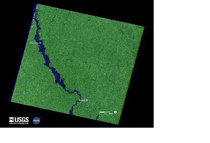
Flooding along the Missouri River continues as shown in recent Landsat satellite images of the Nebraska and Iowa border. Heavy rains and snowmelt have caused the river to remain above flood stage for an extended period.

A Landsat 5 image of the area from May 5, 2011 shows normal flow. In contrast, a Landsat 7 image from July 17 depicts flood conditions in the same location.

A national overview map of streamflow provided by U.S. Geological Survey (USGS) WaterWatch graphically portrays the immense geographic extent of flooding in the Missouri River basin.

Monitoring both floods and droughts, the USGS WaterWatch internet site displays maps, graphs, and tables that describe current and past streamflow conditions for the United States. The real-time streamflow data is generally updated on an hourly basis.

The Landsat Program is a series of Earth-observing satellite missions jointly managed by NASA and the U.S. Geological Survey. Landsat satellites have been consistently gathering data about our planet since 1972.

They continue to improve and expand this unparalleled record of Earth's changing landscapes, for the benefit of all. The next Landsat satellite is scheduled to launch in December 2012.
www.spacedaily.com
Thu, 21 Jul 2011 - 12:10

Footer menu

  • Contact
  • Terms of Use

User account menu

  • Log in