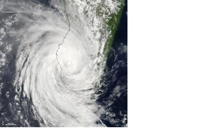
On 23 February 2013, the International Charter "Space and Major Disasters" was activated to provide satellite imagery and maps for responders to Cyclone Haruna. Haruna had had struck southwest Madagascar on Friday 22 February 2013. The Cyclone had made landfall as a Category 2 storm with wind speeds of up to 105 mph. The storm fuelled itself over Mozambique with gusty wind speeds of up to 95mph as it headed towards the island of Madagascar. This map created by OCHA shows Haruna's predicted path on 22 February 2013.
The cyclone’s cloud-filled eye was centred near 23.3 south latitude and 44.2 east longitude on the largest city and capital of Antananarivo, Madagascar.
The worst affected districts are; Morombe, Taolagnaro and Toliary. So far it has been reported that 10 people were killed, 17 people were hurt and nearly 3,000 others were affected and some 1,000 people were evacuated to temporary shelter during the storm.
Over the weekend, the island experienced torrential rains and heavy flooding. The Joint Typhoon Warning Center (JTWC) expects the storm to weaken as it moves back into cooler waters of the Southern Indian Ocean.
The mechanism was triggered by the Direction Générale de la Sécurité Civile et de la Gestion des Crises - COGIC - on behalf of Bureau National de Gestion des Risques et des Catastrophes (BNGRC) - Madagascar. SERTIT will do the project management for this activation. The maps will be made available on the Charter's website as soon as possible.

