• English
  • Español
  • Français

United
Nations


Office for Outer Space Affairs
UN-SPIDER Knowledge Portal

  • Inicio
  • Sobre nosotros
    • Sobre ONU-SPIDER
    • Acerca de UNOOSA
    • Publicaciones
    • Ofertas de trabajo
    • Conozca el Equipo
    • Contacto
  • Aplicación Espacial
    • Guías Tecnológicas
    • Mecanismos de Emergencia
    • Mecanismos de Recuperación
    • Red Internacional de Alerta de Asteroides
    • Grupo Asesor para la Planificación de Misiones Espaciales
    • Iniciativa Internacional sobre Meteorología Espacial
    • Tecnologías Espaciales en la ONU
    • Historias de Usuarios
  • Enlaces y Recursos
    • Aplicación de datos del mes
      • Disaster Recovery
    • Fuentes de Datos
    • SIG y Software de Percepción Remota
    • Recursos de capacitación en línea
    • Instituciones
  • Riesgos y Desastres
    • Gestión del Riesgo de Desastres
    • Alerta temprana
    • Gestión de Desastres y Emergencias
    • Amenazas Naturales
    • El Proceso de la Reducción de Desastres Post-2015
    • La ONU y la Gestión del Riesgo de Desastres
    • La ONU y Alerta Temprana
    • La ONU y la Gestión de Desastres
  • Asesoría
    • Misiones de Asesoría
    • Apoyo en caso de Emergencia
    • Asesoría Virtual
    • Prácticas Recomendadas
    • Actividades de Entrenamiento
    • Usos Prácticos
  • Redes
    • Oficinas Regionales de Apoyo
    • GP-STAR
    • IN-MHEWS
    • IWG-SEM
  • Proyectos
    • SPEAR
    • FOSAT-S
    • EvIDENz
    • Flood GUIDE
  • Noticias y Eventos
    • Noticias
    • Eventos
    • Eventos pasados

Breadcrumb

  • Home
  • NASA/CNES Ocean Satellite Retired After Successful Mission
  • NASA/CNES Ocean satellite retired after successful mission

NASA/CNES Ocean satellite retired after successful mission

 Jason-1 helped to follow changes in the tropical Pacific OceanThe satellite was a joint project of NASA and CNES that lasted for more than eleven years.

The Jason-1 ocean altimetry satellite has been retired after achieving scientific, technical and international success in its life time. The satellite was launched in 2001 as a joint project of the NASA and the Centre National d'Etudes Spatiales (CNES). It was designed to last for three to five years but in fact, Jason-1 has been in orbit and reporting data for more than eleven years. During this time, the satellite has successfully mapped sea level, wind speed and wave height for more than 95 percent of Earth's ice-free ocean every 10 days. This information contributed to create a revolutionary 20-plus-year climate data record of global ocean surface topography that began in 1992 with the launch of the NASA/CNES TOPEX/Poseidon satellite.

Since its launch, the satellite has shown that the global sea levels have risen by nearly 1.6 inches (4 centimeters) as a result of global warming. "The Jason satellite series provides the most accurate measure of this impact, which is felt all over the globe", said John Grunsfeld, associate administrator NASA's Science Mission Directorate in Washington.

"Jason-1 provided one of the most comprehensive pictures of changes in the tropical Pacific Ocean, including the comings and goings of El Nino and La Nina events," said Lee-Lueng Fu, a scientist of the project Jason-1. "These Pacific Ocean climate cycles are responsible for major shifts in sea level, ocean temperatures and rainfall every two to five years and can sometimes be so large that worldwide weather patterns are affected. Jason-1 data have been instrumental in monitoring and predicting these ever-changing cycles."
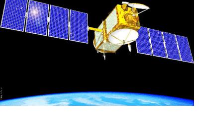
NASA
Mon, 15 Jul 2013 - 08:31

Footer menu

  • Contact
  • Terms of Use

User account menu

  • Log in