• English
  • Español
  • Français

United
Nations


Office for Outer Space Affairs
UN-SPIDER Knowledge Portal

  • Inicio
  • Sobre nosotros
    • Sobre ONU-SPIDER
    • Acerca de UNOOSA
    • Publicaciones
    • Ofertas de trabajo
    • Conozca el Equipo
    • Contacto
  • Aplicación Espacial
    • Guías Tecnológicas
    • Mecanismos de Emergencia
    • Mecanismos de Recuperación
    • Red Internacional de Alerta de Asteroides
    • Grupo Asesor para la Planificación de Misiones Espaciales
    • Iniciativa Internacional sobre Meteorología Espacial
    • Tecnologías Espaciales en la ONU
    • Historias de Usuarios
  • Enlaces y Recursos
    • Aplicación de datos del mes
      • Disaster Recovery
    • Fuentes de Datos
    • SIG y Software de Percepción Remota
    • Recursos de capacitación en línea
    • Instituciones
  • Riesgos y Desastres
    • Gestión del Riesgo de Desastres
    • Alerta temprana
    • Gestión de Desastres y Emergencias
    • Amenazas Naturales
    • El Proceso de la Reducción de Desastres Post-2015
    • La ONU y la Gestión del Riesgo de Desastres
    • La ONU y Alerta Temprana
    • La ONU y la Gestión de Desastres
  • Asesoría
    • Misiones de Asesoría
    • Apoyo en caso de Emergencia
    • Asesoría Virtual
    • Prácticas Recomendadas
    • Actividades de Entrenamiento
    • Usos Prácticos
  • Redes
    • Oficinas Regionales de Apoyo
    • GP-STAR
    • IN-MHEWS
    • IWG-SEM
  • Proyectos
    • SPEAR
    • FOSAT-S
    • EvIDENz
    • Flood GUIDE
  • Noticias y Eventos
    • Noticias
    • Eventos
    • Eventos pasados

Breadcrumb

  • Home
  • India: GIS Used In The Flood Mapping Project To Prevent Damages
  • India: GIS used in the Flood Mapping Project to prevent damages

India: GIS used in the Flood Mapping Project to prevent damages

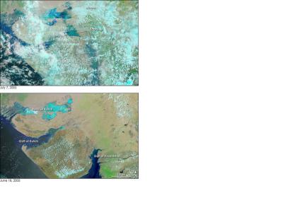
India suffers of severe floodsThe Indian State increase its efforts towards developing a flood mapping project

The Indian State is strengthening efforts towards flood mapping using GIS to assess the vulnerability of selected areas and therefore, be able to prepare the necessary disaster mitigation activities to prevent negative impacts of future floods.

“We are currently analysing the spread of water when released from dams", said an official from the State Government, "Suppose one lakh cusecs of water is released, we must know where it will spread and to what extent will it cause flooding. Similarly, we will study the changes when larger volumes are released”.

To this purpose the State Government of Gujarat will launch a pilot trial of its flood mapping project at the Mahi river basin. Once this is completed the flood mapping project will also be implemented for the Tapi, Sabarmati and Damanganga basins. "This is an important step towards mitigating the threat of floods.”
Asia Pacific Future Gov
Wed, 24 Jul 2013 - 16:10
India

Footer menu

  • Contact
  • Terms of Use

User account menu

  • Log in