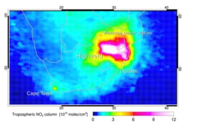
With the goal of improving air quality monitoring and emission inventories, ESA’s GlobEmission project uses Earth observation satellite data in four specific regions: China, India, Europe and South Africa. South Africa constitutes a perfect example of how economic development often comes with an increase of harmful gases that can influence regional air quality and can have an impact on global climate change. Indeed, South Africa’s gross domestic product has grown about 270 billion US dollars just from 2002 to 2012, leading to high levels of air pollutants. To evaluate the effectiveness of air quality improvement initiatives and decide on future strategies, scientists and policy makers use emission inventories, which describe the location and magnitude of emissions from various origins, such as traffic, forest fires or industry.
However, the effectiveness of emission inventories is limited. Recognizing the gaps, ESA began the GlobEmission project, which uses Earth observation satellite data to provide consistent data on atmospheric composition for improved emissions inventories. “In GlobEmission, we use state-of-the-art satellite measurements and computer models to calculate the measured air pollutant concentrations back to their origins,” said Dr Ronald van der A, leader of the GlobEmission project.
Moreover, Dr Bas Mijling from the Dutch meteorological institute KNMI added “The old inventory was especially wrong about the location and strength of emissions by power plants and heavy industry. Using satellite data, however, we can correct their location and update their emission to actual values”.

