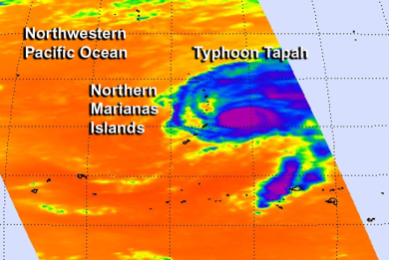
NASA-NOAA’s Suomi NPP satellite started tracing the newborn tropical storm Tapah on 28 April. At the time the storm was still developing close to Guam in the Western Pacific Ocean. The National Weather Service bulletin in Guam issued a warning, since it was expected for the storm to develop into a typhoon the next day.
As the winds reached typhoon speed on 29 April, NASA’s satellite Aqua captured an infra red AIRS image showing the strongest thunderstorms. The Joint Typhoon Warning Center analysed several satellite images and concluded that the storm is already weakening and will be moving into much cooler water, which will slow it even further before reaching the coast of Iwo To, Japan.
On 30 April, again, the Suomi satellite captured Tapah as it weakened from typhoon back to tropical storm. The imagery showed that Tapah’s eye was becoming cloud-filled, but powerful thunder storms were still visible. It is expected that the storm will further weaken as it moves toward Japan.

