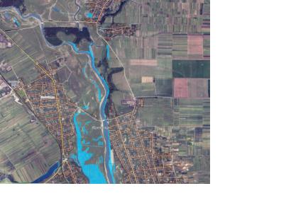
The Romanian Space Agency (ROSA), UN-SPIDER’s Regional Support Office (RSO) in Romania, provided support to the General Inspectorate for Emergency Situations for the activation of the Copernicus GIO Emergency Management Service (EMS) to monitor the floods that affected the southern part of the country at the end of April 2014.
In the framework of the GEODIM project, ROSA, together with the National Meteorological Administration (NMA), helped the national Copernicus GIO EMS-authorized user to trigger the service (call EMSR078), provided reference data and delivered the flood maps to the relevant users (i.e. civil protection and local authorities). In order to raise public awareness related to natural hazards and their effects, the reference and delineation flood maps were immediately published on ROSA’s website.
For Romania, this represents the sixth flood event for which satellite-based maps were created and used by the local authorities for disaster management and emergency response. For the previous flood events, the same team of experts from ROSA and NMA triggered the International Charter: Space and Major Disasters or the former Global Monitoring for Environment and Security Emergency Response Service (GMES ERS). The team created disaster extent and damage assessment flood maps, in addition to the ones delivered by the emergency services.
The International Charter activations were managed by the German Aerospace Center (DLR) in 2005 and 2006, in cooperation with DLR's Center for Satellite Based Crisis Information (ZKI) and by the French Centre National d’Etudes Spatiales (CNES) in 2008, in close collaboration with Service Régional de Traitement d'Image et de Télédétection (SERTIT). GMES ERS was triggered within the SAFER project, during the floods that occurred in 2010.

