• English
  • Español
  • Français

United
Nations


Office for Outer Space Affairs
UN-SPIDER Knowledge Portal

  • Inicio
  • Sobre nosotros
    • Sobre ONU-SPIDER
    • Acerca de UNOOSA
    • Publicaciones
    • Ofertas de trabajo
    • Conozca el Equipo
    • Contacto
  • Aplicación Espacial
    • Guías Tecnológicas
    • Mecanismos de Emergencia
    • Mecanismos de Recuperación
    • Red Internacional de Alerta de Asteroides
    • Grupo Asesor para la Planificación de Misiones Espaciales
    • Iniciativa Internacional sobre Meteorología Espacial
    • Tecnologías Espaciales en la ONU
    • Historias de Usuarios
  • Enlaces y Recursos
    • Aplicación de datos del mes
      • Disaster Recovery
    • Fuentes de Datos
    • SIG y Software de Percepción Remota
    • Recursos de capacitación en línea
    • Instituciones
  • Riesgos y Desastres
    • Gestión del Riesgo de Desastres
    • Alerta temprana
    • Gestión de Desastres y Emergencias
    • Amenazas Naturales
    • El Proceso de la Reducción de Desastres Post-2015
    • La ONU y la Gestión del Riesgo de Desastres
    • La ONU y Alerta Temprana
    • La ONU y la Gestión de Desastres
  • Asesoría
    • Misiones de Asesoría
    • Apoyo en caso de Emergencia
    • Asesoría Virtual
    • Prácticas Recomendadas
    • Actividades de Entrenamiento
    • Usos Prácticos
  • Redes
    • Oficinas Regionales de Apoyo
    • GP-STAR
    • IN-MHEWS
    • IWG-SEM
  • Proyectos
    • SPEAR
    • FOSAT-S
    • EvIDENz
    • Flood GUIDE
  • Noticias y Eventos
    • Noticias
    • Eventos
    • Eventos pasados

Breadcrumb

  • Home
  • MapAction Volunteers Deployed In Response To Flooding In The Balkans
  • MapAction Volunteers deployed in Response to Flooding in the Balkans

MapAction Volunteers deployed in Response to Flooding in the Balkans

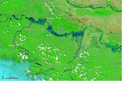
Flooding in the Balkans Satellite Image of the Flooding in the Balkan Peninsula

On 19 May 2014, volunteers from the non-profit crowdsource mapping group MapAction were deployed to Belgrade in response to the severe flooding in Serbia and the Balkans.

In what is being hailed as the worst flood in 120 years reports have indicated that four months worth of rain has fallen in a single day. The flooding caused by excess rain combined with landslides and damage to infrastructure is estimated to have affected over 50,000 people.

The EU Civil Protection Mechanism and other disaster management agencies have been activated in response to the widespread flooding in the Balkans.  As UN-SPIDER reported, the EU Copernicus Emergency Mapping Service was also activated, producing maps for Croatia, Bosnia and Herzegovina and Serbia.

MapAction will be partnering with the UN Disaster Assessment and Coordination team providing information to assess damage and assist in humanitarian aid efforts. This is the charities second emergency deployment in the region. 

UN-SPIDER has compiled a list of available satellite imagery and maps of the flooded regions in the Balkans. 
MapAction
Thu, 22 May 2014 - 11:47
Serbia

Footer menu

  • Contact
  • Terms of Use

User account menu

  • Log in