• English
  • Español
  • Français

United
Nations


Office for Outer Space Affairs
UN-SPIDER Knowledge Portal

  • Inicio
  • Sobre nosotros
    • Sobre ONU-SPIDER
    • Acerca de UNOOSA
    • Publicaciones
    • Ofertas de trabajo
    • Conozca el Equipo
    • Contacto
  • Aplicación Espacial
    • Guías Tecnológicas
    • Mecanismos de Emergencia
    • Mecanismos de Recuperación
    • Red Internacional de Alerta de Asteroides
    • Grupo Asesor para la Planificación de Misiones Espaciales
    • Iniciativa Internacional sobre Meteorología Espacial
    • Tecnologías Espaciales en la ONU
    • Historias de Usuarios
  • Enlaces y Recursos
    • Aplicación de datos del mes
      • Disaster Recovery
    • Fuentes de Datos
    • SIG y Software de Percepción Remota
    • Recursos de capacitación en línea
    • Instituciones
  • Riesgos y Desastres
    • Gestión del Riesgo de Desastres
    • Alerta temprana
    • Gestión de Desastres y Emergencias
    • Amenazas Naturales
    • El Proceso de la Reducción de Desastres Post-2015
    • La ONU y la Gestión del Riesgo de Desastres
    • La ONU y Alerta Temprana
    • La ONU y la Gestión de Desastres
  • Asesoría
    • Misiones de Asesoría
    • Apoyo en caso de Emergencia
    • Asesoría Virtual
    • Prácticas Recomendadas
    • Actividades de Entrenamiento
    • Usos Prácticos
  • Redes
    • Oficinas Regionales de Apoyo
    • GP-STAR
    • IN-MHEWS
    • IWG-SEM
  • Proyectos
    • SPEAR
    • FOSAT-S
    • EvIDENz
    • Flood GUIDE
  • Noticias y Eventos
    • Noticias
    • Eventos
    • Eventos pasados

Breadcrumb

  • Home
  • Algerian Space Agency Tracks Land Use Change With Alsat-2A
  • Algerian Space Agency tracks land use change with Alsat-2A

Algerian Space Agency tracks land use change with Alsat-2A

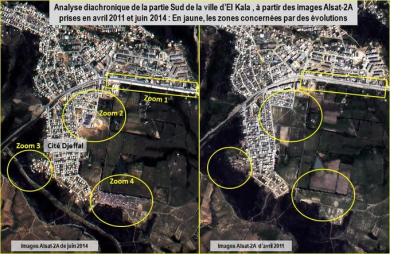
Diachronic analysis of urban and environmental development of El Kala, Algeria.Diachronic analysis of urban and environmental development of the city of El Kala from the images Alsat-2A.

UN-SPIDER’s Regional Support Office in Algeria, the Algerian Space Agency, has recently published the results of bi-phase satellite observations on the towns of El Tarf and El Kala and their surroundings. The goal was to monitor urban sprawl and land use changes that might impact on the environment.

Based on the earth observation satellite imagery, a diachronic analysis using images of Alsat-2A (from two dates: 8 April 2011 and 11 June 2014) was conducted as an effective way of mapping changes in the urban and natural environments. This method of observation highlighted significant changes in construction of infrastructures and dwelling in both cities.

Furthermore, in Oubeira Lake the first stage of eutrophication was detected, a disproportional proliferation of aquatic plants and Lake nutrient, caused by industrial waste and pollution and leading to the reduction of oxygen in water.

Specially, the value of this type of analysis from multi-temporal satellite images, once integrated into a Geographic Information System (GIS), contributes to a database for tracking urban and environmental developments, potentially determinant for decision making, urban planning and environmental protection.
ASAL (French)
Mon, 30 Jun 2014 - 09:25
Algeria
Algeria Regional Support Office

Footer menu

  • Contact
  • Terms of Use

User account menu

  • Log in