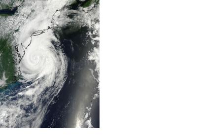
Several satellites kept track and monitored Hurricane Arthur from the initial phases to the development of a Hurricane and to a post-tropical storm.
On 29 June 2014, a low-pressure area in the center east of Florida developed. That area evolved afterward into Tropical Depression 1, captured on June 30 by the MODIS instrument aboard NASA's Aqua satellite.
Hurricane Arthur, the first tropical storm of the 2014 season, subsequently built over the Atlantic and formed off southern Florida.
On 2 July, NASA's Aqua satellite saw a cloud-covered eye as the storm, moving north along the Florida coast. On the way to becoming a hurricane, this image was captured by the Moderate Resolution Imaging Spectroradiometer (MODIS) instrument.
On 3 July, the MODIS instrument on NASA’s Terra satellite acquired an image of the storm over the Bahamas showing that it had become an hurricane. On the same day, the Atmospheric Infrared Sounder (AIRS) instrument aboard NASA's Aqua satellite captured infrared data on Tropical Storm Arthur's cloud tops.
At NASA's Goddard Space Flight Center in Greenbelt, Maryland an analysis of rainfall from TRMM's Microwave Imager (TMI) and Precipitation Radar (PR) instruments was overlaid on a combination visible/Infrared image taken from NOAA's Geostationary Operational Environmental or GOES-East satellite. One of the TRMM Precipitation Radar's most useful functions is its ability to provide 3-D vertical profiles of precipitation from the surface up to a height of about 20 km (12 miles). TRMM PR data were used to create this 3-D view of Hurricane Arthur.
On 5 July, the NASA/NOAA GOES Project created an animation of visible and infrared imagery from NOAA's GOES-East satellite that showed the movement of Arthur from 4 to 5 July as it sped from the U.S. Mid-Atlantic up to eastern Canada. At 8 a.m. EDT on 5 July, satellites saw Arthur weaken, and the National Hurricane Center noted that Arthur has become a post-tropical storm. A cold front has overtaken the circulation of Arthur, helping to change the storm from tropical to post-tropical and to weaken it.
NASA's Terra satellite and NOAA's GOES-East satellite data captured images of Arthur that were made into an animation that tracked its movement up to eastern Canada. On 6 July 2014, the NOAA GOES-East satellite captured an image of Post-Tropical Hurricane Arthur that showed the storm exiting northeastern Canada.

