United
Nations
Office for Outer Space Affairs
UN-SPIDER Knowledge Portal
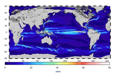
Satellite data collected by ESA’s Gravity Field and Steady-State Ocean Circulation Explorer (GOCE) have been used to create a more accurate gravity map of global ocean currents. Users can register and access the data through ESA's website for free.
The data collected by GOCE, which was operational from 2009 through 2013, were used to measure the gravitational fields of the Earth. The gravitational pull of these fields vary from place to place due to the uneven distribution of mass inside the planet. This has an important impact on the currents of the ocean. In this sense, data provided by GOCE will help scientists to better understand the speed and behaviour of the ocean currents.
The new ocean currents map will mean a great improvement for techniques trying to measure future climate behaviour. On the other hand, the gravity variations data may also be used for other purposes such as monitoring ice mass loss in the Antarctic or the deep-Earth movements that give rise to great quakes.
