• English
  • Español
  • Français

United
Nations


Office for Outer Space Affairs
UN-SPIDER Knowledge Portal

  • Inicio
  • Sobre nosotros
    • Sobre ONU-SPIDER
    • Acerca de UNOOSA
    • Publicaciones
    • Ofertas de trabajo
    • Conozca el Equipo
    • Contacto
  • Aplicación Espacial
    • Guías Tecnológicas
    • Mecanismos de Emergencia
    • Mecanismos de Recuperación
    • Red Internacional de Alerta de Asteroides
    • Grupo Asesor para la Planificación de Misiones Espaciales
    • Iniciativa Internacional sobre Meteorología Espacial
    • Tecnologías Espaciales en la ONU
    • Historias de Usuarios
  • Enlaces y Recursos
    • Aplicación de datos del mes
      • Disaster Recovery
    • Fuentes de Datos
    • SIG y Software de Percepción Remota
    • Recursos de capacitación en línea
    • Instituciones
  • Riesgos y Desastres
    • Gestión del Riesgo de Desastres
    • Alerta temprana
    • Gestión de Desastres y Emergencias
    • Amenazas Naturales
    • El Proceso de la Reducción de Desastres Post-2015
    • La ONU y la Gestión del Riesgo de Desastres
    • La ONU y Alerta Temprana
    • La ONU y la Gestión de Desastres
  • Asesoría
    • Misiones de Asesoría
    • Apoyo en caso de Emergencia
    • Asesoría Virtual
    • Prácticas Recomendadas
    • Actividades de Entrenamiento
    • Usos Prácticos
  • Redes
    • Oficinas Regionales de Apoyo
    • GP-STAR
    • IN-MHEWS
    • IWG-SEM
  • Proyectos
    • SPEAR
    • FOSAT-S
    • EvIDENz
    • Flood GUIDE
  • Noticias y Eventos
    • Noticias
    • Eventos
    • Eventos pasados

Breadcrumb

  • Home
  • Satellites Show Earlier Snowmelt In Wyoming, USA
  • Satellites show earlier snowmelt in Wyoming, USA

Satellites show earlier snowmelt in Wyoming, USA

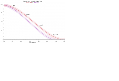
Change in snow cover in analysed decades (Image: NASA)Change in snow cover in analysed decades (Image: NASA)

A new NASA study about snowmelt in Wyoming shows, that the snow in a basin in northwest Wyoming now disappears about 16 days earlier than it did in the period from the 1970s through the 1990s. Snowmelt, as a water source, has a significant impact on agriculture and ecosystems in Wyoming.

For the study, Dorothy Hall, lead author of the study and scientist at NASA’s Goddart Space Flight Center, and her team manually screened more than thousand pictures captured by the Landsat satellite, to create 227 snow maps for the period from 1972 to 2013. The manual work was necessary to avoid cloud caused inaccuracies. About 3000 MODIS images could be analysed automatically. Ground-based stream discharge measurements and daily temperature and precipitation records were also analysed.

“Earlier snowmelt impacts the water resources of most of the state of Wyoming, which has been undergoing a drought since 1999. Monitoring and documenting changes in the timing of snowmelt helps hydrologists plan water resource management for human use and optimize reservoir management,” Hall stated.
NASA
Tue, 31 Mar 2015 - 12:49

Footer menu

  • Contact
  • Terms of Use

User account menu

  • Log in