• English
  • Español
  • Français

United
Nations


Office for Outer Space Affairs
UN-SPIDER Knowledge Portal

  • Inicio
  • Sobre nosotros
    • Sobre ONU-SPIDER
    • Acerca de UNOOSA
    • Publicaciones
    • Ofertas de trabajo
    • Conozca el Equipo
    • Contacto
  • Aplicación Espacial
    • Guías Tecnológicas
    • Mecanismos de Emergencia
    • Mecanismos de Recuperación
    • Red Internacional de Alerta de Asteroides
    • Grupo Asesor para la Planificación de Misiones Espaciales
    • Iniciativa Internacional sobre Meteorología Espacial
    • Tecnologías Espaciales en la ONU
    • Historias de Usuarios
  • Enlaces y Recursos
    • Aplicación de datos del mes
      • Disaster Recovery
    • Fuentes de Datos
    • SIG y Software de Percepción Remota
    • Recursos de capacitación en línea
    • Instituciones
  • Riesgos y Desastres
    • Gestión del Riesgo de Desastres
    • Alerta temprana
    • Gestión de Desastres y Emergencias
    • Amenazas Naturales
    • El Proceso de la Reducción de Desastres Post-2015
    • La ONU y la Gestión del Riesgo de Desastres
    • La ONU y Alerta Temprana
    • La ONU y la Gestión de Desastres
  • Asesoría
    • Misiones de Asesoría
    • Apoyo en caso de Emergencia
    • Asesoría Virtual
    • Prácticas Recomendadas
    • Actividades de Entrenamiento
    • Usos Prácticos
  • Redes
    • Oficinas Regionales de Apoyo
    • GP-STAR
    • IN-MHEWS
    • IWG-SEM
  • Proyectos
    • SPEAR
    • FOSAT-S
    • EvIDENz
    • Flood GUIDE
  • Noticias y Eventos
    • Noticias
    • Eventos
    • Eventos pasados

Breadcrumb

  • Home
  • NOAA: Interactive Storm Surge Map For Flood Risks
  • NOAA: Interactive storm surge map for flood risks

NOAA: Interactive storm surge map for flood risks

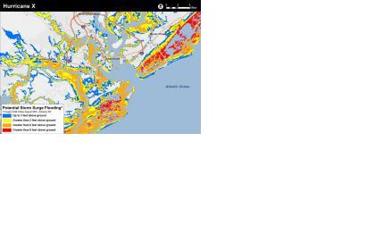
Static example of the experimental potential storm surge inundation map (Image: NOAA)Static example of the experimental potential storm surge inundation map (Image: NOAA)

The National Oceanic and Atmospheric Administration (NOAA) is preparing a new application to help people determine at a street-level where water could rise in a storm surge.

This experimental storm surge simulator will let people get a look at what kind of storm surges can take place in their surroundings and which can be the possible damages. The preliminary model is based on Charleston (South Carolina), USA.

"Surveys of the public show there is still a consistent misunderstanding of what the storm surge is, and how deadly it can be. In part this is due to the challenge scientists encounter in trying to simplify the complex physics of hurricanes for the public, and in part this is due to poor misunderstanding of flood zone maps that represent the flooding scenario as it might be viewed from above," reads the introduction to the app, according to Emergency Management.

Since the feature is still on trial phase, user are called to take a survey before and after using the simulator to help the NOAA’s National Weather Service determine its effectiveness.
Emergency Management
Mon, 13 Apr 2015 - 16:51
Global
United States of America

Footer menu

  • Contact
  • Terms of Use

User account menu

  • Log in