![]()
United
Nations
Tremblement de terre
 Earth Observation Center (EOC) using data acquired by Sentinel-1A before and after the earthquake event. Image: DLR/EOC")
Definition
Facts and figures
Further information
UN-SPIDER Regional Support Offices with hazard-specific expertise
Related content on the Knowledge Portal
 to the plains in the south (right side). Vegetation appears red in this false-colour image, while waterways and buildings appear light green and blue. Image: ESA.")
On 12 March, Nepal Telecommunications Authority (NTA) signed an agreement with French satellite operator Thales Alenia Space to build Nepal’s first communications satellite. The Nepalese government intends to use the satellite to provide nationwide internet access to its citizens, improve disaster management efforts and strengthen economic growth in the country.
The development of Nepal’s own satellite system proves to be significant in terms of improving the country’s disaster management efforts. Nepal is regularly faces natural disasters such as droughts, floods, landslides, fires, and…
read more29/03/2019 ,
,  ,
,  ,
, 
As part of the technical advisory support it provides to countries worldwide, UN-SPIDER carried out an Institutional Strengthening Mission to Myanmar from 11 to 15 March 2019 upon the request of the government. This activity was jointly organized by UN-SPIDER and the United Nations Human Settlement Programme (UN-Habitat), under auspices of the Ministry of Social Welfare, Relief and Resettlement (MSWRR) of Myanmar. It was hosted by the Emergency Operation Centre (EOC). Experts from the Centre for Space Science and Technology Education in Asia and the Pacific (CSSTEAP), the International Centre for Integrated Mountain Development (ICIMOD) and Maxar contributed to the mission.
The mission was a follow-up activity to the UN-SPIDER Technical Advisory Mission (TAM…
read moreRegional Support Offices mentioned:19/03/2019
Earthquakes are a major concern in increasingly populated regions, however their prediction is a difficult task. Researchers have recently made progress in the use of complex simulation and modeling techniques to better forecast the occurrences of earthquakes.
In a recent study, researchers used Gradient Boosted Regression Trees, a machine learning technique for regression and classification problems that incorporates training data, to better determine spatiotemporally complex loading histories within subduction zones. The researchers simulated tens of earthquakes using a small‐scale experimental replica of a subduction zone and show that machine learning predicts well the timing and size of laboratory earthquakes by reconstructing and properly interpreting the spatiotemporally complex loading history of the system. These results promise substantial progress in real earthquake forecasting as they suggest that the complex motion recorded by geodesists at…
read more13/03/2019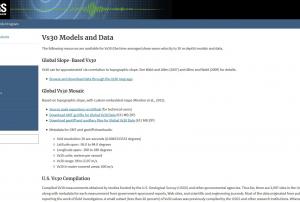 Compiled Vs30 measurements obtained by studies funded by the U.S. Geological Survey (USGS) and other governmental agencies. Thus far, there are 2,997 sites in the United States, along with metadata for each measurement from government-sponsored reports, Web sites, and scientific and engineering journals. Most of the data originated from publications directly reporting the work of field investigators. A small subset (less than 20 percent) of Vs30 values was previously compiled by the USGS and other research institutions. Whenever possible, Vs30 originating from these earlier compilations were crosschecked against published reports.
Both downhole and surface-based Vs30 estimates are represented. Most of the VS30 data are for sites in the western contiguous United States (2,141 sites), whereas 786 Vs30 values are for sites in the Central and Eastern United States; 70 values are for sites in other parts of the United States, including Alaska (15 sites), Hawaii (30 sites),…Publishing institution: From the source: The GEM Foundation's Global Active Faults project (GEM-GAF) is building a comprehensive, global dataset of active fault traces of seismogenic concern. The dataset comprises GIS files hosted here of fault traces and small amount of relevant attributes or metadata (fault geometry, kinematics, slip rate, etc.) useful for seismic hazard modeling and other tectonic applications. The dataset is being assembled primarily as a part of GEM's global Probabilistic Seismic Hazard Modeling efforts, although we hope that the data find wide use in research, education and general interest among many users.Publishing institution:
 Movebank is a free, online database of animal tracking data hosted by the Max Planck Institute for Ornithology. The institute help animal tracking researchers to manage, share, protect, analyze, and archive their data. The animal tracking data in Movebank belongs to researchers all over the world who choose whether and how to share their data with the public. Curretnr esearch is being done on animal derived early warning systems for earthquakes, volcanoes and landslides.Publishing institution:
 ESA's Earth Observation Thematic Exploitation Platform (TEP) is a browser for satellite imagery and specific products on an environmental topic. The TEP platforms are divided into 7 categories: Coastal; Forstry; Geohazards; Hydrology; Polar; Urban; and Food Security. Each platform is a collaborative, virtual work environment providing access to EO data and the tools, processors and Information and Communication Technology resources required to work with them. TEP aims to bridge the gap between the users and the data and tools.Publishing institution:
, 899; https://doi.org/10.3390/rs10060899")
Spanish and Ecuadorian researchers have developed a new methodology to estimate faults and volcanoes that can be activated in a region after an earthquake. The approach consist in evaluating changes of static stress on the surrounding faults and volcanoes and producing maps of potentially activated faults and volcanoes.
The main goal of the study is to achieve an effective transfer of knowledge and scientific techniques to non-expert users who are responsible for the management of disasters and risks.
The study was led by researchers from the European Telecommunications Standards Institute (ETSI) in Topography, Geodesy and Cartography of the Polytechnic University of Madrid (UPM), along with the Complutense (UCM) and the Geological and Mining Institute of Spain (IGME).
These institutions are trying to improve the management of earthquakes and volcanoes through scientific methods using Interferometric Synthetic Aperture Radar…
read more05/11/2018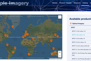 Pleidas, TerraSar-X, SPOT and Elevation data available commercially from airbus, certain sample data sets at various locations available for free.Publishing institution:
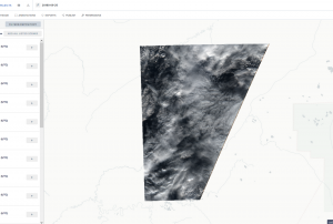 The website: https://www.radiant.earth
Help and Tutorials: https://help.radiant.earth/
Demos & Use Cases: https://demos.radiant.earth/Publishing institution:
UN-SPIDER Regional Support Offices with hazard-specific expertise
![]()