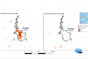
Maps produced by the National Space Activities Commission (CONAE) of Argentina based on satellite images show the notable decrease in nitrogen dioxide (NO₂) during the first days following compulsory isolation due to the COVID-19 outbreak compared to the previous days. The satellite measurements complement those of the surface monitoring stations by giving a perspective of the spatial distribution of the chemical substance.
NO2 is an atmospheric pollutant that is produced when nitrogen monoxide (NO) emitted by the burning of fossil fuels comes into contact with the oxygen in the air. For this reason it is associated with vehicle traffic, air traffic and some industrial activities.