• English
  • Español
  • Français

United
Nations


Office for Outer Space Affairs
UN-SPIDER Knowledge Portal

  • Home
  • About Us
    • What is UN-SPIDER?
    • About UNOOSA
    • Publications
    • Jobs
    • Meet the Team
    • Contact
  • Space Application
    • Satellite Technology
    • Emergency Mechanisms
    • Recovery Mechanisms
    • International Asteroid Warning Network
    • Space Mission Planning Advisory Group
    • International Space Weather Initiative
    • Space Technologies in the UN
    • User Stories
  • Links & Resources
    • Data Applications
      • Disaster Recovery
    • Data Sources
    • GIS and Remote Sensing Software
    • Online Learning Resources
    • Institutions
  • Risks & Disasters
    • Disaster Risk Management
    • Early Warning Systems
    • Emergency and Disaster Management
    • Natural Hazards
    • Sendai Framework
    • The UN and Disaster Risk Management
    • The UN and Early Warning
    • The UN and Disaster Management
  • Advisory Support
    • Advisory Missions
    • Emergency Support
    • Virtual Advisory Support
    • Recommended Practices
    • Training Activities
    • Practical Uses
  • Network
    • Regional Support Offices
    • GP-STAR
    • MHEWS
    • IWG-SEM
  • Projects
    • SPEAR
    • SEWS-D
    • EvIDENz
    • Flood GUIDE
  • News & Events
    • News
    • Events Calendar
    • UN-SPIDER Events Archive
  • Admin
    • SAM Items

Breadcrumb

  • Home
  • News and Events
  • View Active News
  • Argentina: Satellite Images Support Flood Damage Mitigation
  • Argentina: Satellite images support flood damage mitigation

Argentina: Satellite images support flood damage mitigation

5 March satellite image of floods in province of Santa Fe (Image: CONAE)5 March satellite image of floods in province of Santa Fe (Image: CONAE)

The Argentinean National Space Activities Commission (CONAE) has been producing information about recent floods based on radar satellite images. In March, the provinces of Santa Fe and Santiago del Estero suffered from intense floods.

Satellite imagery of the affected areas has served as support for the efforts of national institutions and organisms to mitigate the damages. The imagery was obtained from the Italian Cosmo SkyMed mission as well as from Landsat and SPOT5 satellites.

According to the newspaper La Nación, the floods in Santa Fe and Santiago del Estero were caused by an unusual amount of rainfall in the central area of the country that forced more than 5000 to evacuate and killed 10. It also caused a collapse of the vital infrastructures and daily activities. The rural areas are the most affected with more than 500,000 hectares of crops destroyed.

According to an article in La Nación, experts agree that climate change is one of the main explanations for this increasing rainfall, but take also into consideration the lack of strong infrastructures, the effects of monoculture and the inclusion of non autochthonous flora, among other factors. 
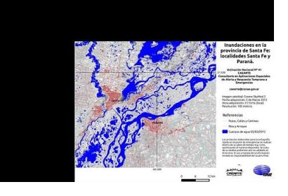
The satellite-based maps are available on CONAE's website.

CONAE is UN-SPIDER's Regional Support Office in Argentina.

CONAE
Tue, 31 Mar 2015 - 15:08
Argentina
Argentina Regional Support Office

Footer menu

  • Contact
  • Terms of Use

User account menu

  • Log in