United
Nations
Office for Outer Space Affairs
UN-SPIDER Knowledge Portal
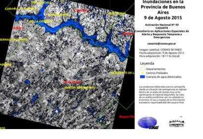
The Argentinean Space Agency (CONAE), UN-SPIDER’s Regional Support Office, has provided satellite data to monitor major flooding caused by the overflow of the Areco and Luján rivers in the province of Buenos Aires.
CONAE is supporting the institutions and organisms in charge of the mitigation activities through satellite images, which show the environmental situation of the covered areas. These images follow a rigorous process of downloading, preprocessing, examination, processing and final elaboration.
Moreover, CONAE has activated the International Charter: Space and Major Disasters together with the SIFEM-DNPC (Sistema Federal de Emergencias - Dirección Nacional de Protección Civil) in order to receive satellite-based emergency information and maps.
The torrential rain, during which it is estimated that 350 millimeters fell, has already caused the death of three people and the evacuation of around 11 thousand.
According to the International Charter, “relief and shelter is being provided to the evacuees as they wait for the flood waters to subside. The rain is expected to continue, but at lower levels than that experienced over the past days.”
