
A new project of the European Space Agency (ESA) aims to combine data from two different Copernicus Sentinel missions to provide estimates of evapotranspiration at the scale of a single field. The European Space Agency’s Sentinels for Evapotranspiration (Sen-ET) project brings together optical data from the Sentinel-2 mission and thermal data from the Sentinel-3 mission to produce evapotranspiration maps at a resolution of 20m. This is not only relevant for sustainable agriculture, but also for water resource management, and can help understand and respond to climate variability, predict droughts and address heatwaves.
Evapotranspiration describes the process of water being transferred from the Earth’s land and ocean surfaces to the atmosphere through evaporation and transpiration from plants. Monitoring evapotranspiration helps identify crops suffering from water stress before damage becomes visible, while also ensuring sustainable water consumption for irrigation.
To derive measures of evapotranspiration at the scale of a single field, the project combines optical and thermal data from the Copernicus Sentinel-2 and Sentinel-3 satellites. Each of the satellite missions carries camera-like instruments, but the resolution of the images they take differ, as does the time it takes them to revisit the same location on Earth. In order to merge the data, the three companies involved in the project - DHI GRAS and Sandholt from Denmark, and the Institute of Agrifood Research and Technology (IRTA) from Spain - use innovative machine-learning techniques.
The consortium has developed an open source plugin for the Sentinel Application Platform (SNAP) software, which facilitates making use of the algorithm and merging the data from both satellites to create evapotranspiration maps. The SNAP plugin is thus beneficial for Earth observation processing and analysis. It can be downloaded from the project page.
This plugin is available for all users and many people are expected to benefit from the developed ET modelling application. Agriculturalists and organizations related to agriculturalists will benefit by being able to produce accurate ET maps for use in agriculture. Scientists and research organizations working in agriculture, hydrology and remote sensing will benefit by being able to access the application’s source code and use it for their needs and experiments. Data providers will benefit by being able to produce ET maps at a range of spatial resolutions and extents. Finally, regional, national and international governmental and non-governmental organizations and initiatives will benefit by being able to derive maps and statistics on agricultural water usage and crop water stress.
Another objective of the project is to provide inputs, which focus on ET estimation and highlight the possibilities and limitations of the current observational capabilities provided by the Sentinel constellation, for requirements gathering and design processes of a possible future ESA thermal mission.
According to DHI GRAS’ Radoslaw Guzinski, “by combining machine-learning sharpening methods and physical models of land-surface processes we are able to optimally fuse the unique characteristics of the Copernicus Sentinel-2 and Sentinel-3 satellites. The resulting evapotranspiration maps, which cannot be produced by relying on one satellite type alone, show that the Sentinel constellation is larger than the sum of its parts.”
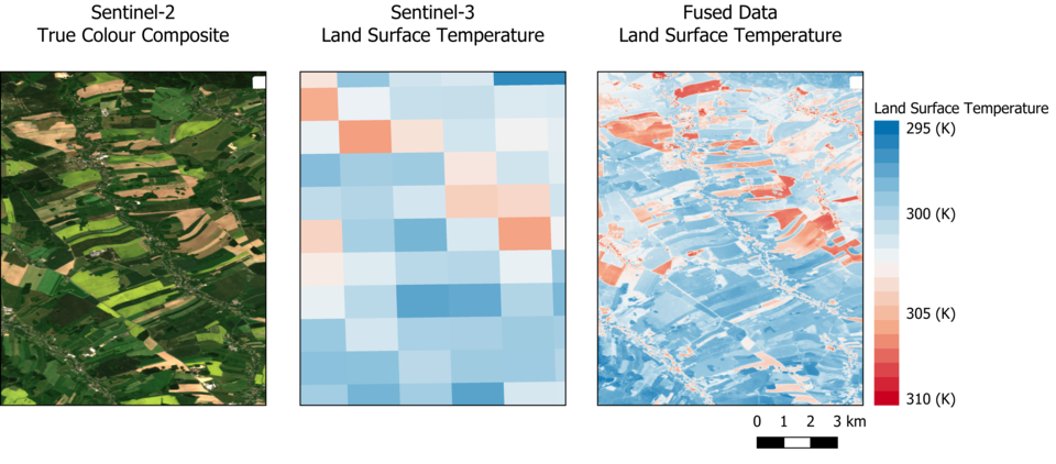
Figure 1. Sentinel-2 and Sentinel-3 satellite images shown separately and fused. Image: ESA.
Considering that monitoring evapotranspiration helps identify crops suffering from water stress before damage becomes visible, means that the open source tool developed is relevant for drought forecasting, as the measurements are key to predicting droughts.
According to the recently published UN World Water Report, agriculture accounts for 70 per cent of all freshwater consumed globally and, therefore, efficient water management is essential. Global water use has increased drastically over the past hundred years and continues to do so, due to increasing population, economic development and shifting consumption. Combining this with the effects of climate change, it becomes apparent that effective and efficient water management will only become more relevant in the future, as will earth-observing satellites to support water management.
Drought monitoring has been a focus area of UN-SPIDER since its establishment in 2006. UN-SPIDER’s project “Earth Observation Based Information Products for Drought Risk Reduction at the National Level” (EvIDENz) aimed at developing new methods and means of communicating Earth observation-based information being developed. Additionally, new Earth observation-based methods to monitor drought hazard characteristics were tested. Another project, “Strengthening Earth Warning System for Drought” (SEWS-D), informs about the use of space-based technology to address the effects of drought on soils and vegetation and strengthen national drought early warning systems, specifically in Central America. UN-SPIDER also has a range of step-by-step procedures, the so-called Recommended Practices, on the use of space-based information for drought monitoring. The Data Applications of the Month on drought monitoring and land degradation monitoring compliment the Recommended Practices and explain how space-based information can be useful in disaster management and points to relevant data sets and other resources.