• English
  • Español
  • Français

United
Nations


Office for Outer Space Affairs
UN-SPIDER Knowledge Portal

  • Home
  • About Us
    • What is UN-SPIDER?
    • About UNOOSA
    • Publications
    • Jobs
    • Meet the Team
    • Contact
  • Space Application
    • Satellite Technology
    • Emergency Mechanisms
    • Recovery Mechanisms
    • International Asteroid Warning Network
    • Space Mission Planning Advisory Group
    • International Space Weather Initiative
    • Space Technologies in the UN
    • User Stories
  • Links & Resources
    • Data Applications
      • Disaster Recovery
    • Data Sources
    • GIS and Remote Sensing Software
    • Online Learning Resources
    • Institutions
  • Risks & Disasters
    • Disaster Risk Management
    • Early Warning Systems
    • Emergency and Disaster Management
    • Natural Hazards
    • Sendai Framework
    • The UN and Disaster Risk Management
    • The UN and Early Warning
    • The UN and Disaster Management
  • Advisory Support
    • Advisory Missions
    • Emergency Support
    • Virtual Advisory Support
    • Recommended Practices
    • Training Activities
    • Practical Uses
  • Network
    • Regional Support Offices
    • GP-STAR
    • MHEWS
    • IWG-SEM
  • Projects
    • SPEAR
    • SEWS-D
    • EvIDENz
    • Flood GUIDE
    • CommonSpace Initiative
    • Tonga Pilot Project
  • News & Events
    • News
    • Events Calendar
    • UN-SPIDER Events Archive

Breadcrumb

  • Home
  • News and Events
  • View Active News
  • Malaysia: Head of Space Agency Promotes Satellite Technology For Disaster Management
  • Malaysia: Head of Space Agency promotes satellite technology for disaster management

Malaysia: Head of Space Agency promotes satellite technology for disaster management

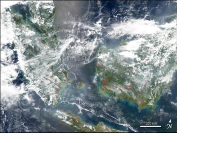
NASA’s Aqua satellite detected fires in Malaysia and Indian Ocean 's islandsNASA’s Aqua satellite detected fires in Malaysia and Indian Ocean's islands in August 2004 (Image: NASA)

The Director-general of the Malaysian National Space Agency (Angkasa), Dr Noordin Ahmad, highlighted the importance of satellite technology in the pre- and post-disaster management phases, as well as during the occurrence of an emergency.

In an interview for the Sun, referring to the National Security Council of the Prime Minister Department, Ahmad stated: "We have engaged them on how best to use and promote the use of satellite technology in mitigating disaster. One way will be to use satellite images in the pre- and post disaster process".

He emphasized the importance of employing satellite imagery in the preventive stage of the disaster management cycle as a way to assist the federal government and local authorities in Malaysia to better understand the characteristics and possible impacts of disasters, and to disseminate useful information for mitigation operations before a disaster occurs.

Moreover, Angkasa's Director-general stressed the usefulness of satellite images in the elaboration of urban and infrastructure plans for a certain area. He highlighted the value for Malaysia to collaborate with other space agencies and international bodies - such as UN-SPIDER and the European Space Agency (ESA) - which can facilitate public and cost-free satellite data for disaster management to developing countries.
theSundaily
Mon, 8 Dec 2014 - 08:06
Malaysia

Footer menu

  • Contact
  • Terms of Use

User account menu

  • Log in