• English
  • Español
  • Français

United
Nations


Office for Outer Space Affairs
UN-SPIDER Knowledge Portal

  • Home
  • About Us
    • What is UN-SPIDER?
    • About UNOOSA
    • Publications
    • Jobs
    • Meet the Team
    • Contact
  • Space Application
    • Satellite Technology
    • Emergency Mechanisms
    • Recovery Mechanisms
    • International Asteroid Warning Network
    • Space Mission Planning Advisory Group
    • International Space Weather Initiative
    • Space Technologies in the UN
    • User Stories
  • Links & Resources
    • Data Applications
      • Disaster Recovery
    • Data Sources
    • GIS and Remote Sensing Software
    • Online Learning Resources
    • Institutions
  • Risks & Disasters
    • Disaster Risk Management
    • Early Warning Systems
    • Emergency and Disaster Management
    • Natural Hazards
    • Sendai Framework
    • The UN and Disaster Risk Management
    • The UN and Early Warning
    • The UN and Disaster Management
  • Advisory Support
    • Advisory Missions
    • Emergency Support
    • Virtual Advisory Support
    • Recommended Practices
    • Training Activities
    • Practical Uses
  • Network
    • Regional Support Offices
    • GP-STAR
    • MHEWS
    • IWG-SEM
  • Projects
    • SPEAR
    • SEWS-D
    • EvIDENz
    • Flood GUIDE
    • CommonSpace Initiative
    • Tonga Pilot Project
  • News & Events
    • News
    • Events Calendar
    • UN-SPIDER Events Archive

Breadcrumb

  • Home
  • News and Events
  • View Active News
  • New Chinese Satellites Will Support Country’s Disaster Management
  • New Chinese satellites will support country’s disaster management

New Chinese satellites will support country’s disaster management

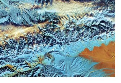
This cropped, false-colour image captured with Sentinel-2A on 18 November 2016, depicts northwestern China. Since the 1960s, the Tian Shan glaciers have lost a quarter of their ice mass and scientists estimate that they will shrink by half until 2050. The melting process of glaciers pose threats to communities living downstream. Image: ESA. This cropped, false-colour image captured with Sentinel-2A on 18 November 2016, depicts northwestern China. Since the 1960s, the Tian Shan glaciers have lost a quarter of their ice mass and scientists estimate that they will shrink by half until 2050. The melting process of glaciers pose threats to communities living downstream. Image: ESA.

After completing in-orbit tests, China officially put two new Earth observation satellites into operation on 21 March. As new part of China’s High-definition Earth Observation Satellite (CHEOS), Gaofen-5 and -6 will aid in environmental protection, agricultural and forestry surveys and disaster relief.

Gaofen-5 and -6 will improve China’s capability to receive ground images and data, thereby facilitating social, economic and environmental development, stated Zhang Kejian, director of the China National Space Administration (CNSA). After launching Gaofen-7 later this year, China will complete the construction of CHEOS with multiple high-definition satellites, Keijan said.

During the testing period of several months, the two satellites provided data on natural resources, environmental monitoring, and natural disasters. According to project managers, the designers of the Gaofen series verified the reliability of the satellites’ equipment concluding that they are prepared for their official start. Both satellites are expected to operate in a sun-synchronous orbit for at least eight years.

Launched on 9 May 2018, Gaofen-5 is the first satellite developed by Chinese researchers and experts to monitor air pollution by examining air pollutants, greenhouse gases and aerosols. Gaofen-5 weighs 2.7 tons and carries six instruments, two for land observation and four for air monitoring. The satellite was designed and constructed by the Shanghai Academy of Spaceflight Technology and is used mainly by the Ministry of Ecology and Environment, the Ministry of Natural Resources and China Meteorological Administration.

Gaofen-6 was launched one month after Gaofen-5 and provides high-resolution images of the Earth. The satellite was developed and built by the China Academy of Space Technology (CAST) in Beijing. According to the academy, Gaofen-6 is China's first satellite capable of performing high-precision agricultural monitoring. The data will support China’s disaster management as it will be used to monitor disasters, estimate crop yields as well as complete surveys of wetland and forest resources. CAST has worked in all of those fields with Gaofen-1, the first one of the satellite fleet launched in April 2013.

China launched the Gaofen project in May 2010 and claimed it to be one of 16 nationally important projects in science and technology. The project’s goal is to form a space-based, high-resolution Earth observation network by 2020.
Two Chinese Earth observation satellites put into service
Mon, 8 Apr 2019 - 09:20
Asia
China

Footer menu

  • Contact
  • Terms of Use

User account menu

  • Log in