
In recent years, Mozambique has suffered severe floods and droughts that have impacted urban and rural communities throughout the country. In the March and April 2019, tropical cyclones Idai and Kenneth triggered major floods in Mozambique, Malawi, Zimbabwe, and Comoros. The Port of Beira was hard hit, as cyclone Idai destroyed transmission lines and bridges, leaving the port without access to these lifelines for several days. In contrast the powerful El Niño event of 2016 triggered major droughts that affected most of the country. Thousands of farmers lost their crops and their cattle and had to rely on humanitarian assistance to cope with the impacts of this event.
Taking into consideration the benefits of the use of satellite imagery to map the geographic extent of floods and to monitor the effects of drought on vegetation; the Federal University of Santa Maria of Brazil (UFSM), in its role as a UN-SPIDER Regional Support Office (RSO); and UN-SPIDER joined forces to conduct a virtual seminar on the use of the UN-SPIDER Recommended Practices to process satellite imagery to map the geographic extent of floods, and to elaborate a series of maps that allow government agencies, as well as regional and international organizations, to assess the severity of droughts in particular years in comparison to droughts in other years. The virtual seminar, conducted on 04 August 2020, brought together more than 30 officers of government agencies of Mozambique, as well as researchers, faculty members and students from various universities.
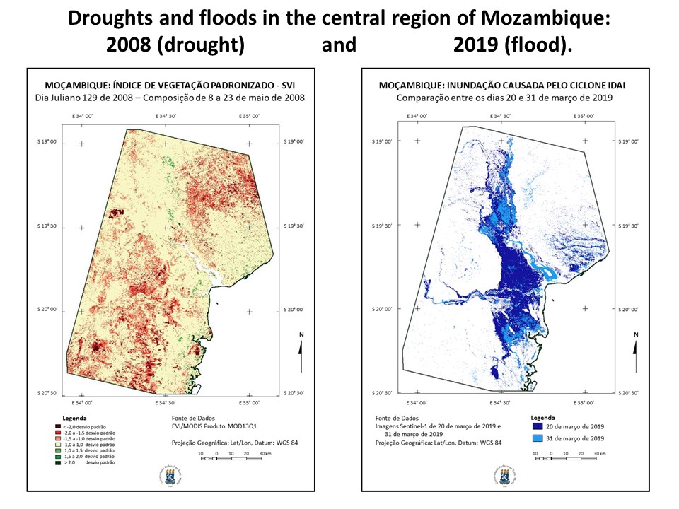
Dr. Pardi Lacruz, one of the researchers and focal point of the UN-SPIDER RSO in Brazil, made participants aware of efforts by the space community to develop drought indices extracted from satellite imagery, that assess the impacts of drought on vegetation. Dr. Pardi then introduced participants to the Standard Vegetation Index (SVI), which allows for the comparison of the severity of droughts in one year with respect to drought in other years. She explained that the UN-SPIDER Recommended Practice makes use of the Enhanced Vegetation Index (EVI) from the MODIS sensors in the Terra and Aqua satellites. In particular, the composite product generated every 16 days. She then presented the results of the SVI maps for Mozambique from February 2000 to June 2020. She noted severe droughts in the years 2005, 2008, and 2016; and then compared droughts in those years with the drought in the year 2020, which is impacting the north eastern region of the country. She commented that this comparison allows for the conclusion that the droughts in 2005 and 2008 were probably more severe than the ongoing drought in 2020.
Dr. de Araujo Sousa Jr., another one of the researchers and focal point of the UN-SPIDER RSO in Brazil, gave participants a brief introduction to the use of radar imagery, which can be used to map the extent of floods even under cloudy conditions. He then presented the results extracted from Sentinel 1 radar images regarding the very large floods triggered by cyclone Idai in March 2019. He concluded his presentation indicating that the maps of flooded areas allowed him to estimate that more than 210,000 hectares of land were flooded by 31 March 2019.
Taking note of these results, participants agreed on the importance of continuing this discussion on the procedures to elaborate different types of maps using satellite imagery and agreed to conduct additional virtual seminars on this topic.