  • English
  • Español
  • Français

United
Nations


Office for Outer Space Affairs
UN-SPIDER Knowledge Portal

  • Home
  • About Us
    • What is UN-SPIDER?
    • About UNOOSA
    • Publications
    • Jobs
    • Meet the Team
    • Contact
  • Space Application
    • Satellite Technology
    • Emergency Mechanisms
    • Recovery Mechanisms
    • International Asteroid Warning Network
    • Space Mission Planning Advisory Group
    • International Space Weather Initiative
    • Space Technologies in the UN
    • User Stories
  • Links & Resources
    • Data Applications
      • Disaster Recovery
    • Data Sources
    • GIS and Remote Sensing Software
    • Online Learning Resources
    • Institutions
  • Risks & Disasters
    • Disaster Risk Management
    • Early Warning Systems
    • Emergency and Disaster Management
    • Natural Hazards
    • Sendai Framework
    • The UN and Disaster Risk Management
    • The UN and Early Warning
    • The UN and Disaster Management
  • Advisory Support
    • Advisory Missions
    • Emergency Support
    • Virtual Advisory Support
    • Recommended Practices
    • Training Activities
    • Practical Uses
  • Network
    • Regional Support Offices
    • GP-STAR
    • MHEWS
    • IWG-SEM
  • Projects
    • SPEAR
    • SEWS-D
    • EvIDENz
    • Flood GUIDE
  • News & Events
    • News
    • Events Calendar
    • UN-SPIDER Events Archive

Breadcrumb

  • Home
  • News and Events
  • View Active News
  • UNOSAT Japan: Satellite Derived Map of Standing Water Bodies, Sendai, Miyagi Prefecture
  • UNOSAT Japan: Satellite derived map of standing water bodies, Sendai, Miyagi prefecture

UNOSAT Japan: Satellite derived map of standing water bodies, Sendai, Miyagi prefecture

UNITAR/UNOSAT tsunami-related  map Japan

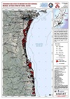
UNITAR/UNOSAT has produced a map of tsunami-related standing water bodies, Sendai, Miyagi prefecture. This map illustrates satellite-detected standing bodies of water remaining after the tsunami event over the city of Sendai and affected areas south in Miyagi Prefecture. Flood waters were identified through an analysis of Radarsat-2 satellite data recorded 12 March 2011 provided through the Space Charter.

UNITAR/UNOSAT works in close collaboration with and support to the Space Charter Project Manager (JAXA) for this event. The satellite image derived data (standing water bodies) can be downloaded from the link - http://www.unitar.org/unosat/node/44/1549.


EARSC on March 18, 2011
Mon, 21 Mar 2011 - 10:16
Japan

Footer menu

  • Contact
  • Terms of Use

User account menu

  • Log in