  • English
  • Español
  • Français

United
Nations


Office for Outer Space Affairs
UN-SPIDER Knowledge Portal

  • Home
  • About Us
    • What is UN-SPIDER?
    • About UNOOSA
    • Publications
    • Jobs
    • Meet the Team
    • Contact
  • Space Application
    • Satellite Technology
    • Emergency Mechanisms
    • Recovery Mechanisms
    • International Asteroid Warning Network
    • Space Mission Planning Advisory Group
    • International Space Weather Initiative
    • Space Technologies in the UN
    • User Stories
  • Links & Resources
    • Data Applications
      • Disaster Recovery
    • Data Sources
    • GIS and Remote Sensing Software
    • Online Learning Resources
    • Institutions
  • Risks & Disasters
    • Disaster Risk Management
    • Early Warning Systems
    • Emergency and Disaster Management
    • Natural Hazards
    • Sendai Framework
    • The UN and Disaster Risk Management
    • The UN and Early Warning
    • The UN and Disaster Management
  • Advisory Support
    • Advisory Missions
    • Emergency Support
    • Virtual Advisory Support
    • Recommended Practices
    • Training Activities
    • Practical Uses
  • Network
    • Regional Support Offices
    • GP-STAR
    • MHEWS
    • IWG-SEM
  • Projects
    • SPEAR
    • SEWS-D
    • EvIDENz
    • Flood GUIDE
  • News & Events
    • News
    • Events Calendar
    • UN-SPIDER Events Archive

Breadcrumb

  • Home
  • SAOCOM 1B
  • SAOCOM 1B

SAOCOM 1B

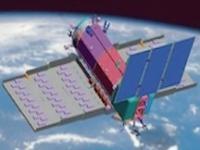
The Argentinean Microwaves Observation Satellite 1B (SAOCOM 1B) was launched into orbit on August 30, 2020 from Space Launch Complex 40 at Cape Canaveral Air Force Station in Florida, United States of America. Developed by the National Argentinean Space Commission (CONAE) in corporation with the Italian Space Agency (ASI), this new satellite joined SAOCOM 1A and four Italian COSMO-SkyMed to complete the Italian-Argentinean Satellite System for Emergency Management (SIASGE). The SAOCOM 1B satellite orbits at 620 km above the earth's surface and is fitted with a Synthetic Aperture Radar (SAR) sensor that makes use of microwaves in the electromagnetic L-band. The spatial resolution of its imagery ranges between 10 and 100 meters. The data collected by SAOCOM 1B helps monitor climatological disasters (forest fires, glacial lake outbursts, droughts) and hydrological disasters (landslides and floods).


30 Aug 2020
5years
Sun synchronous
97 minutes
Synthetic Aperture Radar
CONAE
ASI
Earth observation and emergency management with an L-band SAR.
Forest Fire
Glacial Lake Outburst
Drought
Landslide
Flood
L-Band active Radar
Yes
Information about SAOCOM on ESA's Earth Observation Portal

Footer menu

  • Contact
  • Terms of Use

User account menu

  • Log in