![]()
United
Nations


Step by step: Radiometric intercalibration of multi-source nighttime light images at high resolution for disaster mapping
Radiometric Intercalibration Workflow
Remote sensing images acquired from different satellites may show differences in brightness values because of sensor characteristics and imaging conditions. To make multi-source nighttime light (NTL) images comparable, a radiometric intercalibration process is required. In this practice, SDGSAT-1 and Yangwang-1 images are used as an example to demonstrate the intercalibration workflow.
The procedure consists of three main steps: identifying stable pixels, estimating the regression relationship between sensors, and applying the derived transformation to perform radiometric correction.
1. Identification of Stable Pixels
The first step of radiometric intercalibration is to identify stable pixels that show little change in nighttime light intensity. These pixels are often referred to as pseudo-invariant pixels (PIPs).
Because disasters may cause large variations in nighttime light intensity, not all pixels can be used for model fitting. Therefore, only pixels with relatively stable brightness values between the two images are selected as training samples.
To identify candidate pixels, threshold segmentation is applied to both SDGSAT-1 and Yangwang-1 images to determine lit areas. Only pixels that belong to the common lit area in both images are retained for further analysis.
Let the selected stable pixels from Yangwang-1 be
and the corresponding RGB values from SDGSAT-1 be
where n denotes the number of selected stable pixels.
2. Regression-Based Sensor Relationship Estimation
After selecting stable pixels, a regression model is used to establish the relationship between the two sensors.
In this practice, the RGB bands of SDGSAT-1 brightness value is modeled as a linear combination of Yangwang-1. The regression model can be written as

where
l i is the brightness value of the i-th Yangwang-1 pixel
r i , g i , b i are the RGB values of the corresponding SDGSAT-1 pixel
α0, α1, α2, α3 are regression coefficients
To improve robustness, an iterative regression process is used to remove outliers. The difference between observed and predicted values is calculated as
where L' denotes the predicted Yangwang-1 brightness values obtained from the regression model.
Pixels with large residual errors are removed from the training dataset, and the regression model is recalculated until the model converges.
3. Radiometric Intercalibration
Once the regression relationship between the two sensors has been obtained, it can be applied to all pixels of the SDGSAT-1 image.
The transformed SDGSAT-1 brightness value can be calculated as

where IYangwang-1-like represents the Yangwang-1-like image generated from SDGSAT-1 data.
After this transformation, the resulting image has brightness values that are consistent with Yangwang-1 observations, allowing the two datasets to be used together for further analysis.
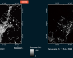
The calibrated Yangwang-1-like image generated from SDGSAT-1 data enables consistent comparison with the observed Yangwang-1 imagery. By combining the pre-disaster Yangwang-1-like image and the post-disaster Yangwang-1 image, a high-resolution nighttime light loss rate map can be derived.
The results shown in Figure 1 demonstrate that the spatial distribution of light loss clearly reflects the impact of disasters. In the Turkey–Syria earthquake cases, large areas with significant nighttime light reduction can be identified in Antakya city.
These high-resolution light loss patterns provide important information about changes in human activities and infrastructure conditions after disasters. Therefore, the radiometric intercalibration approach enables the generation of detailed nighttime light change maps that can support disaster impact assessment, damage evaluation, and post-disaster recovery monitoring.
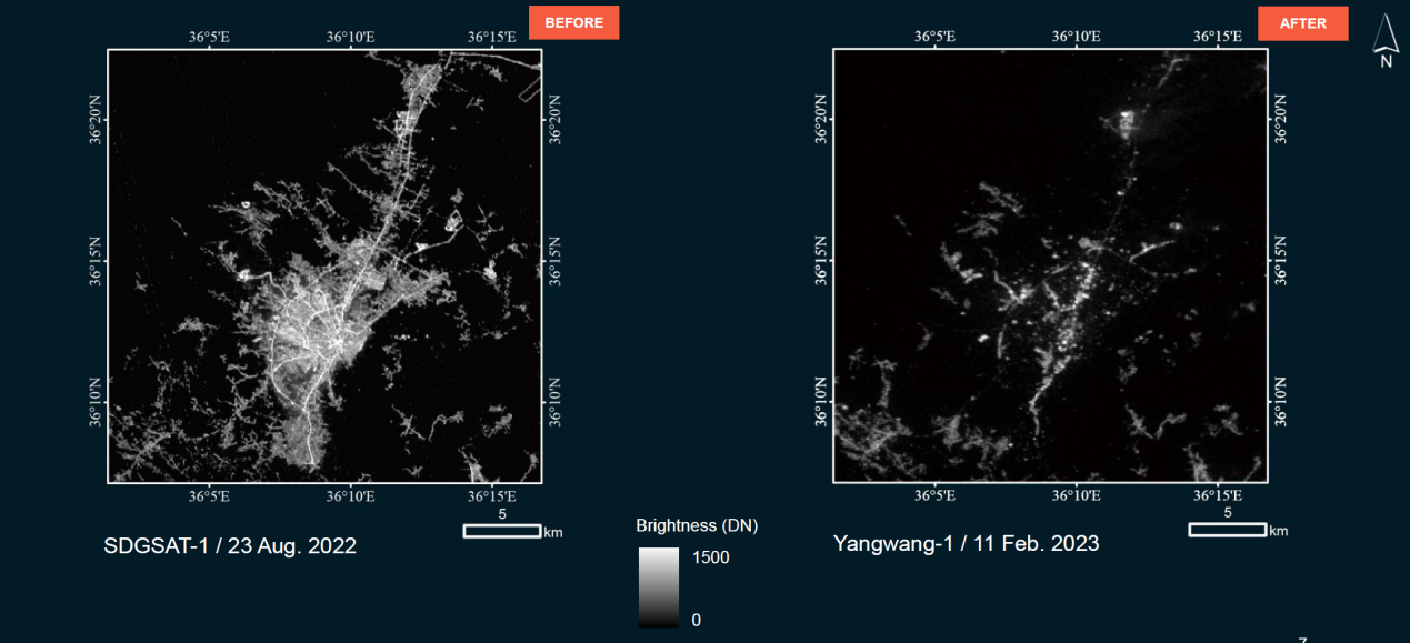
Figure 1. Nighttime light changes in Antakya, Hatay before and after the disaster. The post-disaster Yangwang-1-like image is generated from SDGSAT-1, while the pre-disaster image is acquired by Yangwang-1, enabling consistent comparison of nighttime light intensity.
Image source: UNOSAT report, 2023 (https://unosat.org/products/3497).
In Detail: Radiometric intercalibration of multi-source nighttime light images at high resolution for disaster mapping
Disasters such as earthquakes and conflicts can cause sudden changes in nighttime light. Monitoring these changes is important for understanding disaster impacts and supporting recovery efforts. High-resolution nighttime light (NTL) remote sensing provides detailed observations of human activities and infrastructure conditions at night, making it a valuable data source for disaster assessment. However, NTL images acquired by different satellites often have inconsistent radiometric characteristics, which makes their brightness values difficult to compare directly. Radiometric intercalibration is therefore required to reduce these sensor differences and enable the integration of multi-source NTL datasets.
The recommended practice introduces an automatic radiometric intercalibration workflow for high-resolution nighttime light imagery using SDGSAT-1 and Yangwang-1 data. The procedure identifies stable pixels, estimates the regression relationship between sensors, and applies the derived transformation to generate radiometrically consistent images. The workflow is implemented in Python and provided through an open-source GitHub repository, enabling users to integrate multi-source nighttime light datasets and improve disaster monitoring capabilities.
Background
Disasters such as earthquakes, conflicts can cause sudden changes in nighttime light. These changes can be observed by satellites and analyzed using nighttime light (NTL) remote sensing data. High-resolution NTL imagery provides detailed information about human activities and infrastructure conditions at night, making it useful for disaster assessment and recovery monitoring.
To improve monitoring frequency, researchers often combine NTL images from different satellites. However, images acquired by different sensors may have different radiometric characteristics. These differences make the brightness values difficult to compare directly. Traditional radiometric intercalibration methods usually rely on pseudo-invariant pixels (PIPs), which are areas assumed to remain stable over time. In disaster situations, however, stable reference areas can be difficult to identify because large regions may experience significant changes in nighttime illumination.
In this procedure, an automatic radiometric intercalibration approach is introduced to improve the comparability of high-resolution NTL images from different sensors. The workflow is implemented using Python, and the processing scripts are provided through a public GitHub repository. This approach helps integrate multi-source nighttime light datasets and supports more frequent observations for disaster monitoring.
Radiometric Intercalibration Principle
Radiometric intercalibration is a process used to make satellite images from different sensors comparable. Because different satellites may have different sensor designs, spectral responses, and imaging conditions, the brightness values recorded by each sensor may not be directly consistent. Radiometric intercalibration adjusts these differences so that images from different sensors can be analyzed together.
A common approach for radiometric intercalibration is to first identify stable regions that remain relatively unchanged over time. These areas are often referred to as pseudo-invariant regions or pixels. The brightness values from the stable regions in the two images are then used to establish a regression relationship between the sensors. Once the relationship is obtained, it can be applied to transform the image from one sensor into a radiometrically consistent image with the reference sensor.
Radiometric Intercalibration Workflow
Remote sensing images acquired from different satellites may show differences in brightness values because of sensor characteristics and imaging conditions. To make multi-source nighttime light (NTL) images comparable, a radiometric intercalibration process is required. In this practice, SDGSAT-1 and Yangwang-1 images are used as an example to demonstrate the intercalibration workflow.
The procedure consists of three main steps: identifying stable pixels, estimating the regression relationship between sensors, and applying the derived transformation to perform radiometric correction.
1. Identification of Stable Pixels
The first step of radiometric intercalibration is to identify stable pixels that show little change in nighttime light intensity. These pixels are often referred to as pseudo-invariant pixels (PIPs).
Because disasters may cause large variations in nighttime light intensity, not all pixels can be used for model fitting. Therefore, only pixels with relatively stable brightness values between the two images are selected as training samples.
To identify candidate pixels, threshold segmentation is applied to both SDGSAT-1 and Yangwang-1 images to determine lit areas. Only pixels that belong to the common lit area in both images are retained for further analysis.
Let the selected stable pixels from Yangwang-1 be

and the corresponding RGB values from SDGSAT-1 be

where n denotes the number of selected stable pixels.
2. Regression-Based Sensor Relationship Estimation
After selecting stable pixels, a regression model is used to establish the relationship between the two sensors.
In this practice, the RGB bands of SDGSAT-1 brightness value is modeled as a linear combination of Yangwang-1. The regression model can be written as

where
l i is the brightness value of the i-th Yangwang-1 pixel
r i , g i , b i are the RGB values of the corresponding SDGSAT-1 pixel
α0, α1, α2, α3 are regression coefficients
To improve robustness, an iterative regression process is used to remove outliers. The difference between observed and predicted values is calculated as

where L' denotes the predicted Yangwang-1 brightness values obtained from the regression model.
Pixels with large residual errors are removed from the training dataset, and the regression model is recalculated until the model converges.
3. Radiometric Intercalibration
Once the regression relationship between the two sensors has been obtained, it can be applied to all pixels of the SDGSAT-1 image.
The transformed SDGSAT-1 brightness value can be calculated as
where IYangwang-1-like represents the Yangwang-1-like image generated from SDGSAT-1 data.
After this transformation, the resulting image has brightness values that are consistent with Yangwang-1 observations, allowing the two datasets to be used together for further analysis.

Step by Step:Angular Normalization of Daily Night-time Light Data
Step 1: Angular Normalization
Satellite-observed NTL radiance has a strong nonlinear relationship with the Viewing Zenith Angle (VZA), causing significant time-series fluctuations. This step normalizes the radiance as if the VZA is always zero.
1. Principle:
The angular normalization algorithm is designed to remove the variations in observed night-time light radiance derived from changes in the Viewing Zenith Angle (VZA). Previous research identified a strong nonlinear relationship between night-time light radiance and VZA, which can be expressed as:
Where Z denotes the VZA, R denotes the night-time light radiance, and a, b, and c represent the coefficients. This model is called the Zenith-Radiance Quadratic (ZRQ) model.
The purpose of the normalization algorithm is to estimate the radiance time series assuming the VZA is equal to zero over time. Based on previous studies, we assume that the anisotropy of night-time light radiance remains constant if the land use of an area does not change over a short period. Therefore, the radiance in all directions will change by the same percentage even if the total light emission of the region changes. Based on this basic hypothesis, the radiance of night-time light over a period is modeled as:
Where R (Z,t) epresents the night-time light radiance under the VZA of Z at moment t , c (t) is the actual radiance at moment t assuming the VZA is zero, (α'Z2 + b Z + 1) is the function changing with VZA, and α' and b' are the coefficients. This model effectively decomposes the satellite-observed time series radiance dynamic into two components: the real light emission changes (represented by the radiance at a VZA of zero, c(t) ), and the VZA-change-derived radiance observation due to the anisotropy.
2. Implementation Steps:
1) Define the Objective Function: The algorithm assumes that if land use remains unchanged, the anisotropy of NTL radiance remains consistent over a short period. The goal is to estimate the time series radiance c(t) at a VZA of zero. The objective function minimizes the correlation (R2) between the angle-normalized time series and the VZA using a Zenith-Radiance Quadratic (ZRQ) model.
2) Optimize and Solve:
- Utilize the Nelder-Mead algorithm to minimize the objective function and solve for the required coefficients.
- In Python, this can be implemented using the scipy.optimize.fmin package.
Image Source: Jia et al. 2023 https://doi.org/10.1016/j.jag.2023.103359
Step 2: Time Series Gap-Filling
After obtaining the angle-normalized time series T, we need to use an additive time series model named Prophet to gap-filling the missing data which makes the time series more complete.
The Prophet model is a generalized time series model that can handle various types of patterns, including seasonal and non-seasonal characteristics, which mainly includes the trend term, seasonal term, and the error term. The three terms are optimized by the L-BFGS algorithm to obtain the fitted value. We use the real observation data to fit the time series, and only fill in the fitted values of night-time light radiance at the missing moments thereby completing the time series gap-filling.
Due to the strict filtering criteria in the pre-processing stage (e.g., removing cloud or moonlight contaminated pixels), the resulting time series will have missing data points.
- Apply the Prophet additive time series model to fill in the missing gaps.
- The Prophet model handles seasonal and non-seasonal characteristics by optimizing trend, seasonal, and error terms using the L-BFGS algorithm. Fill in the fitted values only at the missing moments to complete the time series.
Step 3: Estimation of Power Restoration
Once the stable and continuous time series is generated, it can be used to assess disaster damage and track power recovery.
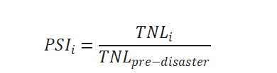
1. Power Supply Index (PSI): Calculate the PSI to quantify the current power supply relative to the pre-disaster baseline.
2. Power Restoration Index (PRI): Calculate the PRI to measure resilience and the chronological progression of recovery from the maximum point of damage.
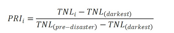
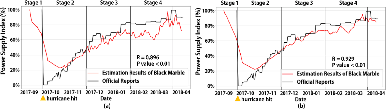
Image Source: Jia et al. 2023 https://doi.org/10.1016/j.jag.2023.103359
![]()