This is event is available for participation on an ongoing basis
Join the Global Flood Partnership May 2026 Webinar Series "Advancing Global Flood Mapping with Earth Observation"! This event will feature three exciting presentations from distinguished experts in the field, focusing on Earth Observation data.
This is event is available for participation on an ongoing basis
Introduction
The Earth Observation (EO) for Resilience and Humanitarian Aid Training Programme is an intensive five-day hybrid course designed to strengthen the ability of UN personnel to use geospatial and satellite-derived information in operational, programmatic, and emergency-response settings. Taking place at the United Nations Office in Vienna from 23-27 March 2026, the programme is jointly delivered by UNOOSA, UNU-INWEH and CEOS agencies (namely, ASI, CNES, DLR and ASI), bringing together technical expertise from across the international EO community.
Origin Space is a Chinese commercial aerospace company and is recognized as the country's first private enterprise dedicated to the exploration and utilization of space resources. The company's long-term vision involves developing mineral resources, such as rare metals, from near-Earth asteroids to support the future of the space industry and humanity.
China will establish the International Research Center of Big Data for Sustainable Development Goals (CBAS), as announced by Chinese President Xi Jinping during his speech at the 75th United Nations General Assembly on September 22, 2020. The purpose of CBAS is to support the implementation of Transforming our world: the 2030 Agenda for Sustainable Development.
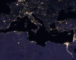
SDGSAT-1 is a single satellite (first of the planned Sustainable Development Science Satellite series) with the prime objectives of land, ocean, urban and environmental monitoring for the UN 2030 Agenda for Sustainable Development Goals (SDGs). The goal of the mission is to provide high-resolution day-and-night synergistic data to support SDG indicators, depicting traces of human activities and their interaction with the Earth environment. To accomplish this the satellite carries three sensors (Thermal Infrared Spectrometer – TIS, Glimmer Imager – GLI, an