  • English
  • Español
  • Français

United
Nations


Office for Outer Space Affairs
UN-SPIDER Knowledge Portal

  • Home
  • About Us
    • What is UN-SPIDER?
    • About UNOOSA
    • Publications
    • Jobs
    • Meet the Team
    • Contact
  • Space Application
    • Satellite Technology
    • Emergency Mechanisms
    • Recovery Mechanisms
    • International Asteroid Warning Network
    • Space Mission Planning Advisory Group
    • International Space Weather Initiative
    • Space Technologies in the UN
    • User Stories
  • Links & Resources
    • Data Applications
      • Disaster Recovery
    • Data Sources
    • GIS and Remote Sensing Software
    • Online Learning Resources
    • Institutions
  • Risks & Disasters
    • Disaster Risk Management
    • Early Warning Systems
    • Emergency and Disaster Management
    • Natural Hazards
    • Sendai Framework
    • The UN and Disaster Risk Management
    • The UN and Early Warning
    • The UN and Disaster Management
  • Advisory Support
    • Advisory Missions
    • Emergency Support
    • Virtual Advisory Support
    • Recommended Practices
    • Training Activities
    • Practical Uses
  • Network
    • Regional Support Offices
    • GP-STAR
    • MHEWS
    • IWG-SEM
  • Projects
    • SPEAR
    • SEWS-D
    • EvIDENz
    • Flood GUIDE
  • News & Events
    • News
    • Events Calendar
    • UN-SPIDER Events Archive

Breadcrumb

  • Home
  • Advisory Support
  • Recommended Practices
  • Recommended Practice: Burn Severity Mapping
  • Recommended Practice: Burn Severity Mapping

Flowchart

Recommended Practice: Burn Severity Mapping

Wildfires can result in the loss of human life. They also have the ability to influence different ecological processes; since they are responsible for partially/completely removing the vegetation layer (Petropoulos, Griffiths, & Kalivas, 2014). Therefore, it is essential to assess the severity of the impacted area. For this reason, this recommended practice was developed to help contribute in the assessment of areas affected by wildfires. The evaluation of these areas can be carried out using different methods; namely, on the ground and using remote sensing tools. The methodology suggested combines the use of Landsat 8 or Sentinel 2 pre- and post-fire imagery, and the Normalized Burn Ration (NBR) index. The recommended practice was designed specifically to assess large areas that have been impacted by wildfires.

Step by Step Burn Severity
In Detail Burn Severity

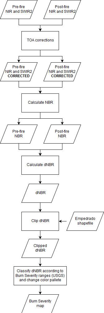
The purpose of this recommended practice is to assist in assessing post-fire burn severity. The methodology applied utilizes the Normalized Burn Ratio (NBR) in pre- and post-fire images; to evaluate the burn severity of the area.

Forest Fire
Recovery & Reconstruction
Relief & Response
Empedrado Commune, province of Talca, Maule region, Chile.

The town of Empedrado presents as a vast area of forests, mainly consisting of pine and eucalyptus trees. Empedrado is a third-level administrative division in central Chile, situated in the Maule region. In this region alone, nearly 4000 people had to evacuate due to the forest fires. At the beginning of February, the Chilean government ended the state of emergency that had been enacted in January 2017. Although forest fires are common during summers in Chile, the combination of a long-term drought, and historically high temperatures, ended up causing one of the worst wildfire seasons the country had ever experienced. The forest fires killed 11 people, caused approximately $333 million in damages, destroyed 1610 houses, and devastated many of the plantations in the area.

Burn severity data and maps can aid in developing emergency rehabilitation and restoration plans, post-fire. The proposed methodology is recommended for assessing the burn severity of large areas that are affected by wildfires. The burn severity can also be used to estimate soil burn severity and the likelihood of future downstream impacts due to flooding, landslides, and soil erosion.

Wildfires: Global Critical Issues

  • Loss of human life and property
  • Air pollution
  • Habitat loss
  • Hydrological regime changes and increased risk of landslides and floods
  • Increased frequency, duration, and severity due to fire suppression methods and climate change

Reference

Petropoulos, G. P., Griffiths, H. M., & Kalivas, D. P. (2014). Quantifying spatial and temporal vegetation recovery dynamics following a wildfire event in a Mediterranean landscape using EO data and GIS. Applied Geography, 50, 120–131.

Recommended by:

Related Practices

Related data

Landsat 8 (NASA)
Earth Explorer (USGS)
Sentinel 2 - Imagery (ESA)

view all

Related Software

RStudio
QGIS
Google Earth Engine (Google)
Python

view all

Disclaimer:

Neither UN-SPIDER nor the Regional Support Offices (RSOs) or their partners take any responsibility for the correctness of outputs from this recommended practice or decisions derived as a consequence.


Footer menu

  • Contact
  • Terms of Use

User account menu

  • Log in