Recommended Practice: Flood Mapping with Sentinel-1 Interferometric Coherence
Due to the geometric characteristics of urban fabric, conventional methods of detecting floods with SAR backscatter in urban areas have major limitations. This is predominantly because of high vertical structures in urban environments, which results in high-intensity signals received at the SAR sensor.
SAR interferometry considers not only the intensity (i.e. the amplitude) of the SAR signal, but also the phase information. Interferometric coherence is defined as the correlation between the phase information of two SAR images: the correlation is calculated for each pixel and is a measure of the change between the two images. InSAR coherence ranges from 0 to 1 with 1 being a high correlation between the phases of the two images and 0 meaning no correlation.
Urban areas do not change much in small temporal time scales, for example between two Sentinel-1 acquisitions. This is why surface changes attributed to disasters, like floods, flash floods or storms, can be mapped by calculating InSAR coherence changes. Therefore, three SAR images are needed: two before the disaster (t1 and t2), acting as reference image and one image shortly after the disaster (t3). The coherence is calculated between the two pre-event scenes (t1-t2) and between the 2nd pre-event scene and the post-event scene (t2-t3).
Important to note is, that outside of urban areas, especially in vegetated areas, coherence decorrelates although significant changes might not have happened. This has to do with the uncertainty connected to SAR signals from vegetation. This is why interpretation of Coherence images will be considered in this practice, as well.
This Recommended Practice aims to map flooded and destroyed areas in urban environments. This practice can be used by users at any experience level, but in-depth interpretation of InSAR coherence images requires a certain level of understanding on how SAR images are acquired. Also drawing reliable conclusions from this analysis might require consulting a specialist in remote sensing. The main part of the analysis is executed in SNAP. The damage assessment is conducted with a Google Earth Engine Script. Additionally, the SNAP output can also serve as a base for more experienced remote sensing analysts to create better flood delineations and damage assessments than the one provided with the Google Earth Engine Script.
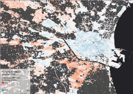
On the 30th of October 2024, the city Valencia in Spain was hit by strong rainfalls, triggering flash floods. More than 200 people were killed during the event and more than 4,000 were evacuated. Satellite technology has played a key role in assessing the damage of the affected areas.
Valuable maps, utilizing different satellite data, were collected by the European Space Agency:
This practice can be used to provide an assessment on the damage of a specific urban area. The output can be regarded as a heat map, providing hotspots of damage attributable to flooding or similar disasters. In addition, the Google Earth Engine code provides information on the settlement density in the affected areas. This information is provided by the Joint Research Centre of the European Commission.
Neither UN-SPIDER nor the Regional Support Offices (RSOs) or their partners take any responsibility for the correctness of outputs from this recommended practice or decisions derived as a consequence.