Floods, as natural disasters, are most commonly caused by storms and torrential rain or by overflowing lakes, rivers or oceans; this type of natural disaster is one of the most common and affects nearly every demographic and area on Earth. As they are wide-ranging disasters, floods leave disaster managers with a wide range of concerns. The immediate concern during a disaster is that of human life and the infrastructure needed to offer emergency response through. Floods can wash away bridges and buildings, destroy electricity systems and even disconnect portions of cities or rural communities from the first responders who need to reach them. Long-term concerns caused by major floods focus on systemic damage: food is often the most serious concern as crops are destroyed and livestock drowns in major flood disasters.
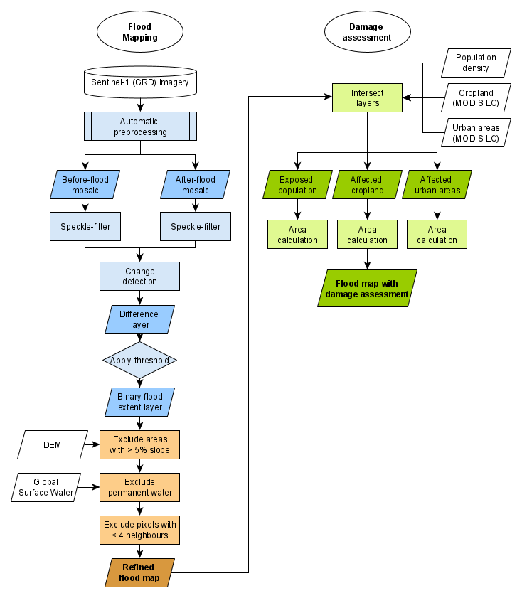
This Recommended Practice aims to create important disaster information for both the short- and long-term concerns of floods. The tool produces a flood extent map using Sentinel-1 SAR images, as well as displays information about cropland and population centers affected in order to address the totality of major concerns that floods cause.
- A Google Earth Engine account is required to use this code. A link is provided in the step-by-step section of this Recommended Practice. Please Note: The account may require a few days to be active.
- Some storage left on Google Drive (20 MB- 1GB, depending on the size of the study area)
- Unlike software-based Recommended Practices, this cloud-based solution has very little hardware requirements as no processing is done on the user’s computer.
- A stable internet connection is required as the processing is done on a cloud-based platform and the results are run through Google Earth Engine’s own JavaScript code.
This Recommended Practice can be used for any large areas with major flooding. The results are scalable, and the area of interest and dates are free for the user to determine. The code pulls data from the Copernicus Programme’s Sentinel-1 satellite and therefore is not able to provide information for any floods before the satellite's launch in July 2014.
Strengths
- The workflow can be easily applied to different areas
- Fully automatically, after specifying the area of interest and time periods
- Very little processing time
- Near-real time monitoring of flood events globally
- Cloud independent flood monitoring
- Cloud-processing allows the use of auxiliary datasets to delineate the flood extent (e.g. slope)
- Provides additional information on exposed population, affected cropland & urban areas
Limitations
- False positives from changes on the land surface, not caused by flooding
- Difficulties of detecting flood in urban or densely vegetated areas
- No capturing of flood peak due to the acquisition frequency of Sentinel-1
- False positives caused by differences in relative orbits
- Border noise errors (when processing large areas)
- Spatial resolution of MODIS Land Cover (500 m) and JRC GHSL Population (250 m) causes uncertainties for the damage assessment
- Notti, D.; Giordan, D.; Caló, F.; Pepe, A.; Zucca, F.; Galve, J.P. Potential and Limitations of Open Satellite Data for Flood Mapping. Remote Sens. 2018, 10, 1673. https://doi.org/10.3390/rs10111673
- Ali, I.; Cao, C.; Naeimi, V.; Paulik, C.; Wagner, W. Methods to Remove the Border Noise From Sentinel-1 Synthetic Aperture Radar Data: Implications and Importance For
Time-Series Analysis. IEEE. 2018, 11, 3. https://doi.org/10.1109/JSTARS.2017.2787650
-
Canty, M. & Nielsen, A. Spatio-temporal analysis of change with Sentinel imagery on the Google Earth Engine. ESA Conference on Big Data from Space (BiDS), Toulouse, France. 28-30 Nov 2017. https://doi.org/10.2760/383579