Japan

country taxonomy block

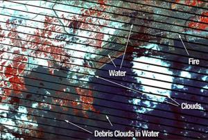
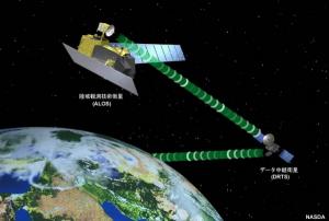
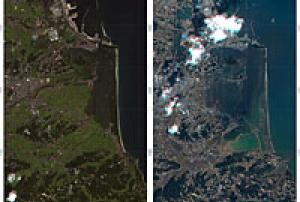
A new GEO Geohazard Supersite on the Tohoku-oki Event was established immediately after the 11 March earthquake and tsunami to aid rescue efforts and advance scientific understanding. Meanwhile, the International Charter on Space and Major Disasters was activated at the request of the Japanese Cabinet and the Japan Aerospace Exploration Agency (JAXA). JAXA is distributing updated PALSAR, ScanSAR and FBS data via its FTP site, and the Italian Space Agency (ASI) is providing data and data products for use by experts.

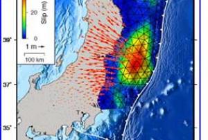
GEO’s Tohoku-oki Event Supersite is pooling the best and most up-to-date images, maps, model results and links on the multiple disasters. The available products address interplate coupling, historic seismicity, and damage; they also include 3D animations of the aftershocks recorded to date.

JAXA has invited modelers and other users of the data it is distributing to share their results with Japan and with the international community as a whole. The…

more
Publishing date 24/03/2011

United Nations agencies are rushing assistance to Japan to help cope with the multi-front disaster caused by last week’s devastating earthquake, tsunami and nuclear power plant breakdown.

The UN International Telecommunication Union (ITU) has already sent emergency equipment to areas severely affected by the tsunami, noting that re-establishing communications is a “critical tool” to ensure timely support for victims and rescue and rehabilitation efforts in the immediate aftermath of a disaster in which more than 5,000 people died, nearly 9,000 others are missing, and vast swathes of coast and infrastructure were overwhelmed by massive waves. Among material already deployed are 78 Thuraya satellite phones equipped with Global Positioning System (GPS) technology to facilitate search and rescue efforts, along with 13 Iridium satellite phones and 37 Inmarsat Broadband Global Area Network terminals.

On the technology front, International Atomic Energy…

more
Publishing date 22/03/2011

After the 2004 Indian Ocean tsunami the international community stepped up its efforts on developing and building early warning systems. Japan is a leading nation with respect to expertise and implementation of both earthquake and tsunami early warning systems. The Tohoku earthquake and the subsequent tsunami that rushed towards and devastated the shores of Honshu island in Japan would have been a substantially larger disaster than it already is, were it not for the well functioning warning systems on the Japanese islands.

An early warning system consist of 4 elements: Risk Knowledge; Warning Service; Dissemination and Response Capability. An effective warning system requires continuous monitoring of our planet; on local, regional and global scales. Several global infrastructures serves various nations needs depending on their particular natural hazards challenges. While there are dedicated instrumental networks for tsunami early warnings, signals from other networks are…

more
Publishing date 22/03/2011

UNITAR/UNOSAT has produced a map of tsunami-related standing water bodies, Sendai, Miyagi prefecture. This map illustrates satellite-detected standing bodies of water remaining after the tsunami event over the city of Sendai and affected areas south in Miyagi Prefecture. Flood waters were identified through an analysis of Radarsat-2 satellite data recorded 12 March 2011 provided through the Space Charter.

UNITAR/UNOSAT works in close collaboration with and support to the Space Charter Project Manager (JAXA) for this event. The satellite image derived data (standing water bodies) can be downloaded from the link - http://www.unitar.org/unosat/node/44/1549.


more
Publishing date 21/03/2011

During and after the Earthquake in Japan, Earth observation technology including buoys, satellites and other imaging devices have allowed scientists and the media to visualize and track the impact of the event, mitigating loss of life and property and supporting effective rescue efforts. Citizen scientists, using cameras, cell phones, video cameras and other tools also have provided valuable visual insights.

Commercial and government managed satellites are becoming key tools for analyzing earthquake and tsunami damage and allocating resources for recovery. By comparing processed before-and-after images of the Japanese landscape and coastline, Japanese officials are able to evaluate the impact of flooding at specific locations. At the same time, organizations which aggregate imagery are working in collaboration with national and international relief organizations to provide timely analysis of situations including the deteriorating status of the nuclear reactors in Japan. The…

more
Publishing date 21/03/2011

One recent entry on the “SpaceAid” satellite tasking page which was posted by the UN Platform for Space–based Information for Disaster Management and Emergency Response (UN-SPIDER) to track the many satellites passing high over Japan following the earthquake and tsunami has attracted very little attention thus far. However, the UN-SPIDER’s knowledge portal confirms that China quickly deployed a pair of smaller earth observation satellites — China’s Huan Jing (HJ)-1-A and B – as part of the broader multinational response to this disaster, and that China’s National Committee for Disaster Reduction (NCDR), and the National Disaster Reduction Center of China (NDRCC) wasted no time in doing so.

The steady growth of the various government-owned satellite fleets in Asia has enormous regional security implications. Thus, any instances where satellite-based cooperation occurs are not to be dismissed or taken lightly. Some of this work…

more
Publishing date 21/03/2011

The aftermath of the catastrophic quake and tsunami in Japan has mobilised unprecedented participation from social networks and crowd sourcing communities around the world. Satellite imagery released for free by major commercial satellite companies earlier this week revealed to the world the extent of the impact of the tsunami waves that hit the east coast of Japan on Friday 11 March. Japan is using various satellite sensors and is coping with the technical work necessary to turn this large amount of data into useful information for rescue and rehabilitation operations. Japan possesses all the technical and scientific capacity necessary to handle satellite mapping and it is a space power itself. For this crisis the role of emergency mapping from entities outside Japan is limited but still useful as a source of additional information and adds a powerful visualisation dimension accessible to the general public worldwide.

UNOSAT is part of a group of specialised players…

more
Publishing date 18/03/2011

Following the massive earthquake and tsunami that hit Japan on 11 March, satellite imagery has been vital in providing a clear picture of the extent of devastation to aid the relief effort now underway. In response to this event, which turned out to be the biggest earthquake Japan has suffered in living memory, the International Charter 'Space and Major Disasters' was triggered by the Cabinet Office of Japan the same day the earthquake struck.

As a result, satellite images from several space agencies and operators from around the world are being used to map and assess the stricken areas.  The value of the initiative lies in the way it has been set up to gather and coordinate a range of different satellite data, turn them into usable products and provide a single access point to the products 24 hours a day, 7 days a week, and at no cost to the user.

Demonstrating the incredible power that Earth can unleash, the devastation caused by the 8.9-magnitude quake has…

more
Publishing date 16/03/2011

In response to the devastating Japan earthquake and tsunami, Esri is providing assistance to a myriad of organizations involved in the disaster response. The company is working closely with both domestic and international agencies to provide on-site personnel, geographic information system (GIS) software expertise, and project services. Esri is also providing organizations with software, data, imagery, and technical support.

GIS solutions are helping officials use critical information for making rapid, effective decisions. The technology helps responders and emergency managers conduct rescue operations, prioritize medical needs, identify severely damaged areas, measure impacts to critical infrastructure, locate areas suitable for food and water distribution, and more.

In addition, an Esri-generated social media mapping application is available for both the media and public. People can follow events in near real time using the application to gain a greater…

more
Publishing date 14/03/2011

After the severe earthquake and tsunami in Japan, the International Charter ‘Space and Major Disasters’ was activated on the morning of the 11 March 2011. All participating institutions were asked to provide satellite imagery of the affected area.

“The information acquired by the German TerraSAR-X radar satellite and the RapidEye imaging satellites, together with data from the American WorldView-2 satellite, show the extent of the disaster,” explains Stefan Voigt, a researcher at DLR. “The advantage of satellite data is the extensive coverage of the disaster area that it provides. At the same time, we can map details with a spatial resolution of down to 50 centimetres. In the maps we have compiled, it can be seen that the tsunami penetrated 4–5 kilometres inland. The severe damage to roads, bridges, buildings and other infrastructure can be clearly seen. This is important information for rescue workers on the ground. We are working closely…

more
Publishing date 14/03/2011

March 11, 2011 will be remembered as the date of one of the largest earthquakes and tsunamis in living history. An 8.9 earthquake, along with massive tidal waves, hit Japan with incredible force, causing catastrophic devastation. As the quake hit and the tsunami moved across the Pacific, earth observation technology including buoys, satellites and imaging devices allowed scientists and the media to visualize and track the impact of the event, mitigating loss of life and property and supporting effective rescue efforts.

Within just one day, UN-SPIDER had developed a database of applicable information and visualizations; the Japanese Meteorological Society had created and distributed 2 and 3-D maps of the event; the USGS had designed a digital poster to explain and describe the event and its impact; NOAA had distributed visualizations of the wave and its path; and international agencies had provided video, maps, images and other tools for managing the crisis.


more
Publishing date 14/03/2011

ESRI and United Nations University (UNU) recently approved a memorandum of understanding (MOU) at the university’s headquarters in Tokyo, Japan. They will collaborate on research, create Centers of Excellence, promote the exchange of graduate students, and provide geographic information system (GIS) training opportunities within and by UNU.

“This agreement will promote enhanced spatial information use in UNU’s research and education initiatives,” said UNU rector and under-secretary-general of the United Nations professor Konrad Osterwalder. “It will also support the increased presence of young researchers at UNU campuses and complement existing and planned research and education programs".

Source: GIS and Science

For full article please visit: …

more
Publishing date 24/02/2010

The Japanese Aerospace Exploration Agency (JAXA) and the German Aerospace Center (DLR) today signed a Letter of Intent (LOI) concerning Mutual cooperation for satellite disaster monitoring.

In this LOI, both parties acknowledged the necessity to promote satellite application, especially Synthetic Aperture Radar (SAR) satellites, as well as related applied research, and to pursue such activities in an international manner.

For further information, please check:
http://www.jaxa.jp/press/2009/08/20090824_dlr_e.html

Publishing date 24/08/2009

The 3rd World Conference on Disaster Risk Reduction will be held from 14 to 18 March 2015 in Sendai City, Miyagi Prefecture, Japan. Several thousand participants are expected, including at related events linked to the World Conference under the umbrella of building the resilience of nations and communities to disasters.

The Second Committee of the United Nations General Assembly Resolution for 2013 on International Strategy for Disaster Reduction states that the 3rd World Conference will result in a concise, focused, forward-looking, and action-oriented outcome document and will have the following objectives:

  • To complete assessment and review of the implementation of the Hyogo Framework for Action;
  • To consider the experience gained through the regional and national strategies/institutions and plans for disaster risk reduction and their recommendations as well as relevant regional agreements within the implementation of the Hyogo Framework of Action;
more

Towards a new science and technology to consolidate disaster risk reduction and sustainable development

This meeting, which takes place prior to the 3rd UN World Conference on Disaster Risk Reduction (3rdWCDRR), will bring together decision makers and leading scientists to discuss how science and technology can contribute to disaster risk reduction and foster sustainable development.

Discussions will be based on the following three viewpoints:

1) It is highly likely that global losses resulting from natural disasters will increase in the future. Early action on recognised disaster risks is essential to sustainable development and to building resilient nations and communities. This conference will explore possibilities to collaborate with Future Earth in the field of earth environmental sciences, and with the Group on Earth Observations (GEO), and to contribute to goal-setting for Sustainable Development Goals on disaster reduction.

2) Reducing disaster risks…

more

OGC and GEO announce joint session on GEOSS in Asia: The Next 10 years November 13, 2014 - Join the Group on Earth Observations (GEO), the Open Geospatial Consortium (OGC) and invited speakers at a special joint session scheduled for December 1st, 1100-1800 (JST), in Tokyo, Japan. The session is intended to provide an overview and discussion on the state of the Group on Earth Observations System of Systems (GEOSS) and the role of OGC and other standards to enable greater interoperability in the context of Asia, with a particular focus on GEO plans for the next ten years. Co-located with OGC’s December technical and planning committee meetings (OGC-TC/PC), speakers will present on a variety of topics including: Introduction to the Group on Earth Observation GEO/GEOSS and the Role of the Infrastructure Implementation Board (IIB) and the GEOSS Common Infrastructure (GCI) OGC’s role in GEO - Results from the Architectural Implementation Pilot The Vision and Architecture for…

more

Over the last decades there has been an increase in weather-related disasters, changes in societal structures, and advancements in weather prediction technologies. The session will examine in particular experiences in early warning. The integration of geospatial technology as part of risk communication has been a key to success to early warning systems and risk information application by governments, businesses and individuals. The identification of policies and regulations; the prioritization of disaster risk reduction and climate change adaptation investment options; the development of sovereign risk financing options; the design of risk-sensitive business models; and better risk management decision-making has added to more effective early warning.

UNOOSA/UN-SPIDER is co-organizing this side event with its partners with the following objectives:

1. To review the progress made in the field of early warning at all levels, particularly with the implementation of EWS…

more

The session during the Third UN World Conference on Disaster Risk Reduction (WCDRR) will demonstrate how new innovations in the application of earth observation, satellite imagery, geographic and geospatial information and ICT can support the implementation of the post-2015 framework for disaster risk reduction. The session will share good practices and examples of the practical application of satellite and earth observation data, service and information for disaster risk reduction. Emphasis will be on the users of satellite data and services to identify areas for improvement and increased cooperation. The session will highlight how local communities, particularly in developing countries, have benefitted from these advanced technologies through the sharing geospatial information between remote areas where no conventional communication infrastructure is available. These technologies have also enabled decision-makers and the general public to employ geospatial information in an easy-…

more

This public forum is focusing on enhancing society's resilience towards future catastrophic disaster by providing the possible and severe disaster scenarios and leading actions of citizens this public forum aims to provide an opportunity to share the advances of disaster management system by fusion of simulation, sensing and geo-informatics, and to discuss its utilization and future perspectives.

The forum: Enhancing Disaster Resilience by Fusion of Simulation, Sensing and Geospatial Information is taking place on Sunday 15 March 09:30 - 17:00

more

March 2015 is the goal for implementation of the Hyogo Framework for Action 2005-2015 (HFA) which was adopted at the World Conference on Disaster Reduction (WCDR) held in Kobe, Hyogo in 2005. Taking this opportunity, the Asian Conference on Disaster Reduction 2015 (ACDR2015) will be held on 15 March 2015 in Sendai, Japan, on the occasion of the Third UN World Conference on Disaster Risk Reduction (WCDRR), 14-18 March 2015. The ACDR2015 will be held as a public forum of the WCDRR in order to confirm achievements of HFA, to clarify the core actions on improving capacity for disaster risk reduction in post-HFA, and to provide an opportunity to discuss our future activities. Sentinel Asia Step3 introduction leaflet and its Case studies were distributed at ACDR2015 in the TKP Garden City Sendai-Kotodai.

more

 The IEEE Geoscience and Remote Sensing Society and the IGARSS 2019 Organizing Committee invites you to Yokohama, Japan for IGARSS 2019 that will be held from Sunday July 28th through Friday August 2nd, 2019 at Convention Center "PACIFICO Yokohama".

This will be the 39th annual IGARSS symposium and will continue the tradition of gathering world-class scientists, engineers and educators engaged in the fields of geoscience and remote sensing. The additional scientific themes of this event, focusing on 'Disasters and Environment' will allow the formation of an inspiring technical program.

IGARSS is recognized today as a premier event in remote sensing and provides an ideal forum for obtaining up-to-date information about the latest developments, exchanging ideas, identifying future trends in your research area and making contacts with the international remote sensing community. With intensive and careful planning underway we anticipate a…

more

The International Consortium on Landslides (ICL) and the ISDR-ICL Sendai Partnerships 2015-2025 announce the  5th World Landslide Forum (WLF5) to be held November 2-6, 2020, in Kyoto Japan. 

This Forum will include a mid-term review of the ISDR-ICL Sendai Partnerships, voluntary contribution to the Sendai Framework 2015-2030 and the Agenda 2030 – Sustainable Development Goals, especially Goal 11 "Make cities and human settlements inclusive, safe, resilient and sustainable".

Participants of the Fourth World Landslide Forum adopted the …

more

GeoEarth-2020 welcomes colleagues from all branches of Geosciences and from many countries in the world to participate to the second edition of thw 'World Congress on Geology and Earth Science'. The Conference will enable the sharing of best practices in Geoscience as well as exploring the role of remote sensing in monitoring Earth processes and dynamics.

The topics of the Conference include:

  • Environmental Geology, 
  • GIS, Remote Sensing and Geospatial Sciences, 
  • Marine Geosciences and Oceanography,
  • Groundwater and Hydrology: Surface Hydrology/Surface Water,
  • Rock Deformation and Structural Geology,
  • Volcanology and Plate Tectonics,
  • Earth, Ecology and Ecosystems,
  • Soil Science and Conservation of Soil Biodiversity.
more
The International Consortium on Landslides and the Global Promotion Committee of International Programme on Landslides will organize the Fifth World Landslide Forum (WLF5) on 2-6 November 2021 in Kyoto, Japan. The aim of this Forum is to promote and share knowledge and best practices about landslide risk mitigation, monitoring and early warning.
 
The forum will discuss the following topics:
  • Sendai Landslide Partnerships and Kyoto Landslide Commitment
  • Hazard and vulnerability mapping and zonation
  • Remote sensing for landslide risk mitigation
  • Technologies for monitoring and early warning
  • Testing, modeling and risk assessment
  • Catastrophic landslides: causes and consequences
  • Frontiers of landslide science and innovative practices
  • Specific topics in landslide science and applications


more

The role of information technology (IT) in disaster situations is becoming more critical in this recent years, especially in mitigating and reducing the risks associated with the disaster effects. Modern information and communication technologies can significantly facilitate the decision-making processes from the point of view of disaster risk reduction.

Disaster risk reductions require multidisciplinary efforts. People from various backgrounds, such as industry, diverse geographical and global settings, non-profit organization backgrounds, agriculture, marine life, welfare, risk management, emergency management, safety engineering, and social networking services, are examples, to name a few. At present, at global and national levels, a wide range of scientific research activities, not only applied research but also theoretical and methodological development and scientific-applied research activity in the area of disaster risk reduction are vastly developed research areas…

more