Climatological
Definition
UN-SPIDER Regional Support Offices with hazard-specific expertise
Related content on the Knowledge Portal
- read moreThe major thrives of this congress will be discuss and develop an integrated Climate Resilience Ecosystem that will address Future Disaster Risk Reduction and Capacity Development of Vulnerable Communities for Sustainable & Inclusive Growth and Subsequently publish a White Paper that will be submitted to the Government of India and the State Government.The Conference will discuss different topics, including:
- Application of GIS & Remote Sensing for Integrated Disaster Risk Reduction
- Costal Vulnerability and Adaption strategies
- Water Security and Risk Management
- Management of Solid Waste for Sustainable Development
- Climate and Carbon Financing
- Sustainability and Inclusive Growth
- Extreme weather Events
- Global Warming and Coastal Risks
- Multi hazard Early Warning Systems
- Water Resource Sustainability and Security
- Application of GIS& RS for…
GeoEarth-2020 welcomes colleagues from all branches of Geosciences and from many countries in the world to participate to the second edition of thw 'World Congress on Geology and Earth Science'. The Conference will enable the sharing of best practices in Geoscience as well as exploring the role of remote sensing in monitoring Earth processes and dynamics.
The topics of the Conference include:
- Environmental Geology,
- GIS, Remote Sensing and Geospatial Sciences,
- Marine Geosciences and Oceanography,
- Groundwater and Hydrology: Surface Hydrology/Surface Water,
- Rock Deformation and Structural Geology,
- Volcanology and Plate Tectonics,
- Earth, Ecology and Ecosystems,
- Soil Science and Conservation of Soil Biodiversity.
The 2020 United Nations/Austria Symposium "Space Applications for Sustainable Development Goal 13: Climate Action" organized by UNOOSA will take place from 1-3 September. It will discuss how space technologies support climate action.
Climate action is one of the most pressing priorities for action within the Sustainable Development Goals framework. The last 5 years were the hottest on record and 14 of the 15 hottest years have occurred since 2000. Average sea levels have risen by 23 cm since 1880 and by 9 cm in the last 25 years. Earth observation is an essential tool to monitor these changes: out of the 50 essential climate change variables, 26 can only be measured from space. Space technologies can contribute significantly to global efforts to mitigate and adapt to climate change. This becomes evident when mapping contributions of space-based technologies to the SDGs: out of the 169 SDG targets, 65 are reliant on geolocation or Earth observation.
…
read more- Publishing institution:
EGU2020: Sharing Geoscience Online (#shareEGU20) brings part of the activities of the EGU General Assembly 2020 online. Participants will join meetings, share their research and discuss with colleagues.
The event will include topics such as:
- Geochemistry, Mineralogy, Petrology Volcanology
- Hydrological Sciences
- Natural Hazards
- Nonlinear Processes in Geosciences
- Ocean Sciences
- Planetary & Solar System Sciences
- Seismology
- Stratigraphy, Sedimentology & Palaeontology
- Soil System Sciences
- Solar-…
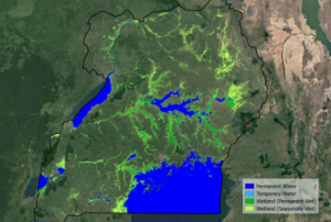
The European Space Agency’s (ESA) GlobWetland Africa project has produced maps that demonstrate how satellite observations can be used for the effective use and management of wetlands in Africa. The project, created in collaboration with the African Team of the Ramsar Convention on Wetlands, provides national and international stakeholders with the necessary satellite-based methods and tools useful for the conservation and effective management of wetlands.
The initiative provides a software platform built on the free and open-source QGIS geographic information system (GIS). The platform shows how optical and radar observations combining long-time data sets from different satellites can be used for studying wetland status and trends. For instance, the project shows how it is possible to map wetland habitat…
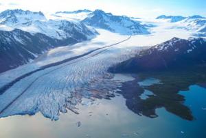
read more20/02/2020Scientists from 50 scientific institutions, led by the National Aeronautics and Space Administration (NASA) and the European Space Agency (ESA) combined 26 independent satellite datasets to show that the Greenland Ice Sheet melt is increasing. The group studied data from 1992 to 2018, taking direct measurements of the continent-sized glacier. The study found that decade averages for ice melt has increased sevenfold from the 1990s.
The report shows that 1992 to 2002 averaged 1mm/decade in melt, 2008 to 2018 increased to a 7mm/decade loss. The research pulled from USGS’s Landsat mission, the oldest open-access Earth observation data. The total was also calculated using space-based gravity measurements - which measures total mass on the world’s largest island - integrated with remotely sensed height…
read more03/02/2020- The Global Ecosystem Dynamics Investigation (GEDI) produces high resolution laser ranging observations of the 3D structure of the Earth. GEDI’s precise measurements of forest canopy height, canopy vertical structure, and surface elevation greatly advance our ability to characterize important carbon and water cycling processes, biodiversity, and habitat. GEDI’s data on surface structure are valuable for weather forecasting, forest management, glacier and snowpack monitoring, and the generation of more accurate digital elevation models.Publishing institution:
- ESA's Earth Observation Thematic Exploitation Platform (TEP) is a browser for satellite imagery and specific products on an environmental topic. The TEP platforms are divided into 7 categories: Coastal; Forstry; Geohazards; Hydrology; Polar; Urban; and Food Security. Each platform is a collaborative, virtual work environment providing access to EO data and the tools, processors and Information and Communication Technology resources required to work with them. TEP aims to bridge the gap between the users and the data and tools.Publishing institution:


