![]()
United
Nations
Earthquake
 Earth Observation Center (EOC) using data acquired by Sentinel-1A before and after the earthquake event. Image: DLR/EOC")
Definition
Facts and figures
Further information
UN-SPIDER Regional Support Offices with hazard-specific expertise
Related content on the Knowledge Portal


On 7 November 2012 at 10:35 am local time, the southwestern region of Guatemala was impacted by a strong earthquake that provoked fatalities and losses. The 7.4 magnitude earthquake had its epicenter 35 kilometers south of the Port of Champerico in the Retalhuleu Department. The National Coordinating Agency for Disaster Reduction of Guatemala (CONRED) conducted a damage and needs assessment and confirmed that most damages took place in the highlands. CONRED indicated that the effects of the earthquake were most felt in communities in San Marcos, Huehuetenango, Quiche, Quetzaltenango, Totonicapan and Solola Departments. In its bulletin number 2943 of 8 November, CONRED indicated that 52 people were killed, 14 injured and 22 missing. The earthquake also damaged severely more than 500 houses. In addition, the institution commented that 20 temporary shelters have been opened in communities in Quiche, Quetzaltenango and San Marcos; providing shelter to 762 persons thus far.
On 8…
read moreThis article discusses aspects of communication architecture for early warning systems (EWS) in general and gives details of the specific communication architecture of an early warning system against tsunamis. While its sensors are the “eyes and ears” of a warning system and enable the system to sense physical effects, its communication links and terminals are its “nerves and mouth” which transport measurements and estimates within the system and
read more
eventually warnings towards the affected population. Designing the communication architecture of an EWS against tsunamis is particularly challenging. Its sensors are typically very heterogeneous and spread several thousand kilometers apart. They are often located in remote areas and belong to different organizations. Similarly, the geographic spread of the potentially affected population is wide. Moreover, a failure to deliver a warning has fatal consequences. Yet, the communication infrastructure…When stricken by a catastrophic natural disaster, emergency rescue operation is very critical to many lives. Many people trapped in the disastrous areas under collapsed buildings or landslides may have a large chance to survive if they are rescued in "Golden 72 Hours". Victims rescued from the debris and
read more
evacuated from their home jammed in shelters need life support material to support their lives. They also need to communicate to each other for various reasons. However, communication systems were usually down due to various reasons. The loss of communication systems and information networks made the rescue and relief operation extremely difficult. Many people died before they got a chance to be rescued. This paper analyzes the causes that paralyzed the entire communication systems in Jiji/Taiwan Earthquake and proposes a MANET based communication platform as well as a Rescue Information System
for Earthquake Disasters that can support a large…Terra is a multi-national, multi-disciplinary satellite mission involving partnerships with the aerospace agencies of Canada and Japan. Managed by NASA’s Goddard Space Flight Center, the mission also receives key contributions from the Jet Propulsion Laboratory and Langley Research Center. The Terra spacecraft houses five major instruments; three of these – ASTER, MODIS and MISR – have been actively supporting the process of visualizing the disaster in Japan. Together with commercial and international satellite images, Terra instruments are measuring and visualizing earthquake and tsunami damage, and may even provide visualization of heat created by the damaged Fukushima Daiichi nuclear reactors.
In addition to satellite-based imagery, NASA is also developing computer models using real-time GPS data to predict and manage events such as earthquakes and tsunamis. Y. Tony Song and his colleagues at NASA’s…
read moreMultiple earthquakes, with the strongest two measuring 5.7 and 5.6 on the Richter scale, struck the mountainous rural regions of Yunnan and Guizhou, in the Yiliang and Weining counties in southwest China on Friday 7 September 2012, killing at least 80 people and injuring more than 160 others. As a result of the earthquakes in this mountainous area, landslides have also been experienced. The most serious damage was in Yiliang county, where the majority of the fatalities occurred. An estimated 100,000 people have been evacuated and approximately 20,000 houses were destroyed. The mountainous terrain in the region is making relief efforts to remote locations difficult.
Upon request from the National Disaster Reduction Centre of China (NDRCC), UNOOSA/UN-SPIDER immediately placed a request to the National Remote Sensing Centre (NRSC) of Indian Space Research Organisation (ISRO) and DigitalGlobe to task high resolution satellite imagery collection of the earthquake-hit area. The…
read moreMulti-temporal very high resolution satellite imagery offers the ability to monitor multi-temporal land use and land cover changes at unprecedented scales and areas. Such capabilities are particularly suited for acquiring detailed information of land cover changes in the immediate aftermath of a disaster event. The Image Information Mining virtual Laboratory experiment focused on the use of such imagery to map the effects of the 2009 L'Aquila earthquake. This paper describes semi-automatic change detection workflows to map earthquake damage. Such workflows include essential steps to improve the quality of change detection such as radiometric normalization and image co-registration. In addition, this article describes the various pre-processing steps that are used to improve consistency between images. This paper also discusses the ability to export results into formats more suitable for stakeholders such as geospatial analysts.
read more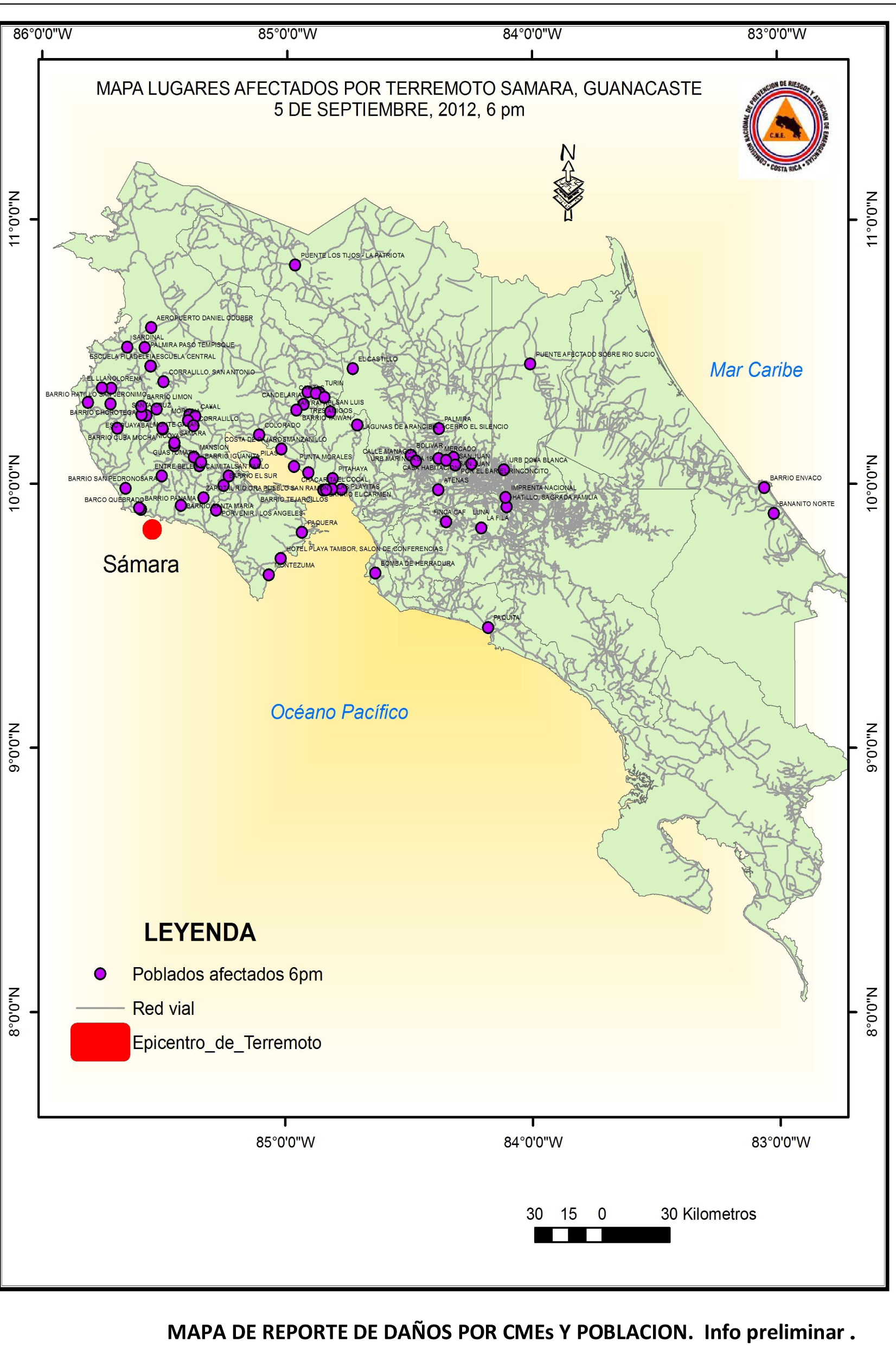 The coast of Costa Rica was struck on 5 September 2012 at 08:42 a.m. local time by a major earthquake with the epicenter located in the Nicoya Península. The United States Geological Survey (USGS) indicated a magnitude of 7.6. on the Richter scale. The epicenter is located very close to the surface, approximately in a depth of 10 kilometres. A tsunami warning was in effect for Costa Rica, Panama and Nicaragua, issued by the Pacific Tsunami Warning Centre but it was cancelled two and a half hours later based on data gathered from tide gauges. A map displaying the epicenter was provided by Geographer Douglas Salgado from the National Risk Prevention and Emergency Response Commission of Costa Rica (CNE).
UN-SPIDER's Regional Support Office (RSO) in Panama has tasked NASA's EO-1 satellite to…
read more
UN-SPIDER Regional Support Offices with hazard-specific expertise
![]()