Hydrological
Definition
UN-SPIDER Regional Support Offices with hazard-specific expertise
Related content on the Knowledge Portal
EO4GEO aims to bridge the skills gap between the supply and demand of education and training in the space/geospatial sectors, fostering the uptake and integration of space/geospatial data and services in a broad range of application domains.
The event includes sessions on:
- Introduction to Copernicus and Services (with COVID-19 examples)
- The role of Earth Observation in emergency situations
- NO2 Air pollution monitoring
- Three case studies on how satellite data combined with other data is valued for agriculture, nature conservation and monitoring of forest for detection of fire and diseases
- The role of EO in emergency situations
- Maritime Spatial Planning.
The training date is in the past. However, videos and resources of the training can be accessed here.
Groundwater makes up roughly 30% of global freshwater. It also provides drinking water for the world’s population and irrigation for close to one third of global agricultural land. Because of this level of reliance, monitoring groundwater is crucial for water resources and land management. The Gravity Recovery and Climate Experiment (GRACE) and GRACE-Follow On (GRACE-FO) missions from NASA and the German Research Centre for Geosciences (GFZ) provide large-scale terrestrial water storage estimation from mid-2000 to present. The mission uses twin satellites to accurately map variations in the Earth's gravity field and surface mass distribution.
GRACE observations have been used for detecting groundwater…
read moreThe International Water Management Institute (IWMI) and Digital Earth Africa (DEA) have partnered to develop tools and applications that will support water resource management and water security in Africa. The applications will use remote-sensing and machine learning technologies and will produce measurements that can improve the understanding of Africa’s changing landscape and provide African governments, communities, and companies with insights, knowledge, and analysis to make more informed and strategic decisions.
IWMI and DEA will first develop an application for water accounting that can produce timely and quality information to better understand water use and availability, water risks, water quality, water values and efficiency, water allocations across different sectors, and the downstream…
read more11/05/2020EGU2020: Sharing Geoscience Online (#shareEGU20) brings part of the activities of the EGU General Assembly 2020 online. Participants will join meetings, share their research and discuss with colleagues.
The event will include topics such as:
- Geochemistry, Mineralogy, Petrology Volcanology
- Hydrological Sciences
- Natural Hazards
- Nonlinear Processes in Geosciences
- Ocean Sciences
- Planetary & Solar System Sciences
- Seismology
- Stratigraphy, Sedimentology & Palaeontology
- Soil System Sciences
- Solar-…
This symposium will explore address the use of a decade of SMOS (Soil Moisture and Ocean Salinity) data for climate research. Many processes, especially related to climate, occur on temporal and spatial scales that are well beyond the lifetime of an individual mission. Ten years of SMOS data are hence a valuable long-term consistent satellite data records to study these processes and to understand changes in the Earth System, for example in the global water or carbon cycle. In addition, longer data records increase the level of confidence in estimating extreme events, such as droughts or tropical cyclones.
The symposium is open to scientists and engineers interested in exploring the capabilities of 10 years of SMOS data, also in synergy with other space or ground based data sources, for climate applications.The topics that will be discussed are:
- Relevance of 10 years of SMOS data for climate research and international climate activities (Sustainable…
As well as providing critical information about ice, CryoSat has also demonstrated that it can offer a valuable source of data for oceanography, hydrology and geodesy.
The conference therefore provides a forum for international scientists and operational users to present and share state-of-the-art CryoSat-based results, its decadal contribution to science and future perspectives in the following areas:
- Sea ice
- Greenland and Antarctica icesheets
- Glaciers and ice caps
- Oceans and marine gravity
- Hydrology
- Icebergs & ice shelves
- 10 Years of operations, synergies and future missions
- MERIT Hydro is a global hydrography datasets, developed based on the MERIT DEM and multiple inland water maps. It contains flow direction, flow accumulation, hydrologically adjusted elevations, and river channel width., High-resolution raster hydrography maps are a fundamental data source for many geoscience applications. Here we introduce MERIT Hydro, a new global flow direction map at 3 arc-second resolution (~90 m at the equator) derived from the latest elevation data (MERIT DEM) and water body datasets (G1WBM, GSWO, and OpenStreetMap). We developed a new algorithm to extract river networks near-automatically by separating actual inland basins from dummy depressions caused by the errors in input elevation data. After a minimum amount of hand-editing, the constructed hydrography map shows good agreement with existing quality-controlled river network datasets in terms of flow accumulation area and river basin shape. The location of river streamlines was realistically aligned with existing satellite-based global river channel data. Relative error in the drainage area was smaller than 0.05 for 90% of GRDC gauges, confirming the accuracy of the delineated global river networks. Discrepancies in flow…Publishing institution:
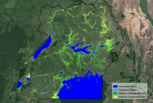
The European Space Agency’s (ESA) GlobWetland Africa project has produced maps that demonstrate how satellite observations can be used for the effective use and management of wetlands in Africa. The project, created in collaboration with the African Team of the Ramsar Convention on Wetlands, provides national and international stakeholders with the necessary satellite-based methods and tools useful for the conservation and effective management of wetlands.
The initiative provides a software platform built on the free and open-source QGIS geographic information system (GIS). The platform shows how optical and radar observations combining long-time data sets from different satellites can be used for studying wetland status and trends. For instance, the project shows how it is possible to map wetland habitat…
read more20/02/2020These training materials provide an introduction to the Ensemble Framework for Flash Flood Forecasting (EF5) system developed by SERVIR Applied Sciences Team PI Yang Hong, Co-I Zac Flamig, and Race Clark of the University of Oklahoma. The EF5 is a hydrologic modeling system that allows for the prediction and monitoring of floods, as well as drought conditions. The resources available include a full training package, containing all documents, data, software, examples, and presentations.
Training materials are available at http://ef5.ou.edu/training/and https://www.youtube.com/channel/UCgoGJtdeqHgwoYIRhkgMwog.
To access these resources from the GitHub repository, go to https://github.com/HyDROSLab/EF5.


