• English
  • Español
  • Français

United
Nations


Office for Outer Space Affairs
UN-SPIDER Knowledge Portal

  • Home
  • About Us
    • What is UN-SPIDER?
    • About UNOOSA
    • Publications
    • Jobs
    • Meet the Team
    • Contact
  • Space Application
    • Satellite Technology
    • Emergency Mechanisms
    • Recovery Mechanisms
    • International Asteroid Warning Network
    • Space Mission Planning Advisory Group
    • International Space Weather Initiative
    • Space Technologies in the UN
    • User Stories
  • Links & Resources
    • Data Applications
      • Disaster Recovery
    • Data Sources
    • GIS and Remote Sensing Software
    • Online Learning Resources
    • Institutions
  • Risks & Disasters
    • Disaster Risk Management
    • Early Warning Systems
    • Emergency and Disaster Management
    • Natural Hazards
    • Sendai Framework
    • The UN and Disaster Risk Management
    • The UN and Early Warning
    • The UN and Disaster Management
  • Advisory Support
    • Advisory Missions
    • Emergency Support
    • Virtual Advisory Support
    • Recommended Practices
    • Training Activities
    • Practical Uses
  • Network
    • Regional Support Offices
    • GP-STAR
    • MHEWS
    • IWG-SEM
  • Projects
    • SPEAR
    • SEWS-D
    • EvIDENz
    • Flood GUIDE
  • News & Events
    • News
    • Events Calendar
    • UN-SPIDER Events Archive
  • Admin
    • SAM Items

Breadcrumb

  • Home
  • Landsat 7
  • Landsat 7

Landsat 7

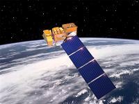
The government-owned Landsat 7 was successfully launched on April 15, 1999, from the Western Test Range of Vandenberg Air Force Base, California, on a Delta-II expendable launch vehicle. The Earth observing instrument on Landsat 7, the Enhanced Thematic Mapper Plus (ETM+), replicates the capabilities of the highly successful Thematic Mapper instruments on Landsats 4 and 5.
Landsat 7 is the most accurately calibrated Earth-observing satellite, i.e., its measurements are extremely accurate when compared to the same measurements made on the ground.  Landsat 7’s sensor has been called “the most stable, best characterized Earth observation instrument ever placed in orbit.”  Landsat 7’s rigorous calibration standards have made it the validation choice for many coarse-resolution sensors.
Considered a calibration-triumph, the Landsat 7 mission went flawlessly until May 2003 when a hardware component failure left wedge-shaped spaces of missing data on either side of Landsat 7’s images.

Instrument: Enhanced Thematic Mapper Plus (ETM+)
- fixed "whisk-broom"
- 8 multispectral bands (wavelength 0.45 - 12.5 µm)
- spectrally-filtered radiation in VNIR, SWIR, LWIR
- achieves 183 km swath
 

15 Apr 1999
5years
Polar
Sun synchronous
99 minutes
ETM+
NASA
NOAA
USGS
Extending and improving upon the long-term record of medium-resolution multispectral imagery of the Earth’s continental surfaces provided by earlier Landsat satellites
Drought
Glacial Lake Outburst
Harmful Algal Bloom
Landslide
Earthquake
Extreme Temperature
Flood
Forest Fire
Mass Movement
Tsunami
Volcanic Eruption
No
Information about Landsat 7 on NASA web page

Footer menu

  • Contact
  • Terms of Use

User account menu

  • Log in