![]()
United
Nations
Tormenta severa

Definition
Facts and figures
Further information
UN-SPIDER Regional Support Offices with hazard-specific expertise
Related content on the Knowledge Portal
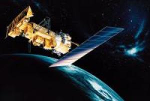
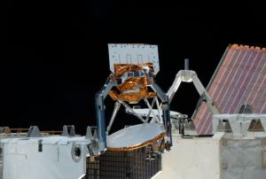
NOAA-15 (designated NOAA-K before launch) is one of the NASA-provided TIROS series of weather forecasting satellite run by NOAA. It was launched on May 13, 1998, and is currently operational, in a sun-synchronous orbit, 807 km above the Earth, orbiting every 101 minutes. It hosts the AMSU-A and AMSU-B instruments, the AVHRR and High Resolution Infrared Radiation Sounder (HIRS/3) instruments, as well as a Space Environment Monitor (SEM/2).
Instruments:
read more
AMSU-A (Advanced Microwave Sounding Unit - A)
AMSU-B (Advanced Microwave Sounding Unit - B)
AVHRR/3 (Advanced Very High Resolution Radiometer/3)
HIRS/3 (High Resolution Infra Red Sounder/3)
S&RSAT (Search & Rescue Satellite-Aided Tracking System)
DCS/s (Data Collection System/2)
SEM/MEPED (SEM/Medium energy proton detector)
SEM/...13/05/1998 27/11/1997
 27/11/1997
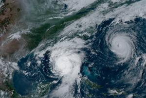
La Nina and Warm Ocean Temperatures Drive Increased Tropical Activity
Forecasters of the National Oceanic and Atmospheric Administration of the United States (NOAA) at the Climate Prediction Center anticipate an above-normal hurricane season in the Atlantic basin for 2024. The season, spanning from June 1 to November 30, holds an 85% likelihood of above-normal activity, with predictions suggesting 17 to 25 named storms. Among these, 8 to 13 are expected to become hurricanes, including 4 to 7 major hurricanes of Category 3 or higher.
Several climatic factors contribute to this heightened activity. Near-record warm ocean temperatures in the Atlantic, the development of La Nina conditions in the Pacific, reduced Atlantic trade winds, and decreased wind shear are all conducive to storm formation and intensification.
As one of the strongest El Ninos on record transitions to La Nina, conditions favoring Atlantic hurricane...
read more29/05/2024
Le Centre Asiatique pour la Prévention des Catastrophes (ADRC) et le Bureau des Affaires Spatiales des Nations Unies (UNOOSA) ont signé l'accord de coopération sur l'établissement du Bureau Régional d'Appui (BRA) ONU-SPIDER de l'ADRC à l'occasion de la 52ème session du Comité des Utilisations Pacifiques de l'Espace Extérieur (COPUOS) le 4 juin 2009.

NASA has developed two weather instruments known as COWVR (Compact Ocean Wind Vector Radiometer) and TEMPEST (Temporal Experiment for Storms and Tropical Systems) to test the potential of low-cost sensors in weather forecasting. The instruments have exceeded expectations and deliver useful forecast information, particularly for tropical cyclones.
COWVR measures wind speed and direction at the ocean surface, while TEMPEST provides atmospheric water vapor measurements. Both instruments, launched in late 2021 to the International Space Station, use microwave emissions to provide internal structure data of tropical cyclones, even if it is obscured by clouds. NASA created these tools with a design that prioritized simplicity, compactness, and the use of mature technology, minimizing the number of moving parts involved. COWVR is about the size of a minifridge, weighs about 60 kilograms, and requires about 47 watts to run, whereas TEMPEST is about the size of a cereal box and...
read more20/03/2023
As the arrival of spring increases the risk of severe weather, NOAA's geostationary and polar-orbiting satellites, such as GOES East, GOES West, Suomi NPP, and NOAA-20, are closely monitoring the changing weather patterns.
GOES-16 and GOES-18 satellites provide real-time information about cloud properties, such as overshooting tops, gravity waves, and above-anvil cirrus plumes, as well as the temperature of cloud tops. This data helps forecasters track weather conditions, identify the severity of a storm, determine wind speeds, and predict the movement of the storm. In addition, these satellites use the Geostationary Lightning Mapper (GLM) instrument to monitor lightning activity, detecting total lightning activity and providing information about the extent and distance of lightning flashes. Scientists are also using AI to train the ProbSevere LightningCast model, which can predict lightning up to an hour before the first observation of lightning flashes, helping...
read more17/03/2023
Term Parents
UN-SPIDER Regional Support Offices with hazard-specific expertise
![]()