• English
  • Español
  • Français

United
Nations


Office for Outer Space Affairs
UN-SPIDER Knowledge Portal

  • Inicio
  • Sobre nosotros
    • Sobre ONU-SPIDER
    • Acerca de UNOOSA
    • Publicaciones
    • Ofertas de trabajo
    • Conozca el Equipo
    • Contacto
  • Aplicación Espacial
    • Guías Tecnológicas
    • Mecanismos de Emergencia
    • Mecanismos de Recuperación
    • Red Internacional de Alerta de Asteroides
    • Grupo Asesor para la Planificación de Misiones Espaciales
    • Iniciativa Internacional sobre Meteorología Espacial
    • Tecnologías Espaciales en la ONU
    • Historias de Usuarios
  • Enlaces y Recursos
    • Aplicación de datos del mes
      • Disaster Recovery
    • Fuentes de Datos
    • SIG y Software de Percepción Remota
    • Recursos de capacitación en línea
    • Instituciones
  • Riesgos y Desastres
    • Gestión del Riesgo de Desastres
    • Alerta temprana
    • Gestión de Desastres y Emergencias
    • Amenazas Naturales
    • El Proceso de la Reducción de Desastres Post-2015
    • La ONU y la Gestión del Riesgo de Desastres
    • La ONU y Alerta Temprana
    • La ONU y la Gestión de Desastres
  • Asesoría
    • Misiones de Asesoría
    • Apoyo en caso de Emergencia
    • Asesoría Virtual
    • Prácticas Recomendadas
    • Actividades de Entrenamiento
    • Usos Prácticos
  • Redes
    • Oficinas Regionales de Apoyo
    • GP-STAR
    • IN-MHEWS
    • IWG-SEM
  • Proyectos
    • SPEAR
    • FOSAT-S
    • EvIDENz
    • Flood GUIDE
  • Noticias y Eventos
    • Noticias
    • Eventos
    • Eventos pasados

Breadcrumb

  • Home
  • Geoscience Australia To Develop a Satellite System For Bushfire Monitoring
  • Geoscience Australia to develop a satellite system for bushfire monitoring

Geoscience Australia to develop a satellite system for bushfire monitoring

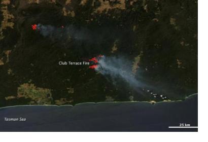
Satellite image of blazing bushfires in Victoria, Australia (Source: NASA)Satellite image of blazing bushfires in Victoria, Australia (Source: NASA)

Geoscience Australia is working on a real-time satellite system for bushfire monitoring that would send images to emergency services and the Australian public every 10 minutes, a spectacular increase in frequency as these captures are currently available every six hours. The programme, called “Sentinel”, is part of the National Emergency Management Projects (NEMP), funded by the Federal Government, and it should be launched by mid-2016.

The imagery will be captured by Himawari-8, a weather satellite operated by the Japan Meteorological Agency, launched in October 2014. It features a 16 channel multispectral imager to capture visible light and infrared images of the Asia-Pacific region. The data will be sent directly to firefighters via a live web feed, and another public facing web service will also be established.

Dr Chris Pigram, director of Geoscience Australia, stated that "the system will be able to measure hotspots from four times a day to 144 times a day. This increase in frequency means that emergency management services will be able to monitor fire development in real time. If we combine this with information from the Bureau of Meteorology we will be able to model very accurately where the fire will move, how [it will move] and how it will respond." 
ABC News
Wed, 12 Aug 2015 - 16:05
Australia

Footer menu

  • Contact
  • Terms of Use

User account menu

  • Log in