United
Nations
Office for Outer Space Affairs
UN-SPIDER Knowledge Portal
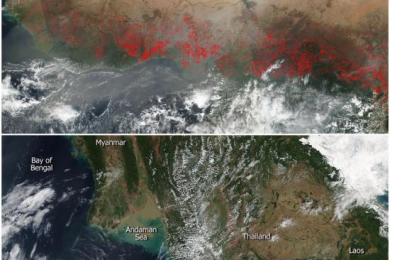
NASA’s Suomi NPP satellite’s VIIRS instrument (Visible Infrared Imaging Radiometer Suite) collected natural-color images from Central Africa and Indochina, where farmers prepare their land for seasonal planting by deliberately setting fire. Fire is used to return nutrients to the soil and to clear the ground in these parts of the world. Although it helps enhance the crops, it produces smoke that plays a significant role in the seasonal air pollution, as it degrades the air quality.
The hotspots which appear as red marks are the areas where the thermal detectors on the VIIRS instrument recognized temperatures higher than background. If they are accompanied by smoke, they are diagnosed as fire. Actively burning areas are outlined in red.
Related links:
https://www.nasa.gov/image-feature/goddard/2017/central-africa-completely-lit-up
https://www.nasa.gov/image-feature/goddard/2017/agricultural-fires-cover-indochinas-landscape
