![]()
United
Nations
SEDAC Hazards Mapper (NASA)
| Data provided by: | National Aeronautics and Space Administration (NASA) |
| Data accessibility: | Visualización de datos (ej. web SIG o monitoreo en tiempo real), Procesamiento web/computación en la nube |
| Link to the data: | |
| File type: | webmap |
| Data type: | Datos sobre amenazas específicas |
| Hazard: | Forest Fire, Earthquake, Flood, Pollution |
| Disaster cycle phase: | Gestión des Riesgo por Desastres, Respuesta, Recuperación |
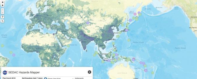
| Space-based Information: | The Hazards Mapper home page is a base map of the world with darker shaded areas indicating higher population densities. Custom population estimates generated by the Hazards Mapper are provided by SEDAC’s Population Estimation Service (PES). Population and settlement data are based on SEDAC’s Global Rural-Urban Mapping Project (GRUMP) and Gridded Population of the World, version 3 (GPWv3) data collections. GPWv3 provides a resolution of roughly 4 km (2.5 miles) at the equator. This population resolution will increase significantly when the updated version, GPWv4, is released in 2016. “Our new population layer will be at a resolution of 1 km (0.6 miles) at the equator, which will give higher precision for smaller areas,” says de Sherbinin. Continuously updated data layers that can be overlaid on the base map are available from NASA’s EOSDIS, including data from SEDAC; NASA's Land, Atmosphere Near real-time Capability for EOS (LANCE); and Global Imagery Browse Services (GIBS). Additional data are available from sources including USGS and NOAA. , The default base map includes: Red dots indicating fires and other hotspots detected over the past 48 hours by NASA’s Moderate Resolution Imaging Spectroradiometer (MODIS) instrument; Colored circles indicating earthquakes over the past seven days from the USGS Earthquake Hazards Program; Icons indicating the location of individual dams, dam clusters, and nuclear power plants from SEDAC’s Global Reservoir and Dam and Population Exposure Estimates in Proximity to Nuclear Power Plants, Locations databases; and, Colored polygons indicating tornado and flood warnings issued by NOAA (U.S. locations only). |
| Spatial coverage: | Global |
| Spatial resolution: | ~750m |
| Temporal coverage: | Casi en tiempo real |
| Content dates: | Last 7 days for Earthquakes, Fires 48 hours |
| Technical Specifications: | |
| Costs: | Gratis |
| Contact: | Contact |
| Tutorials on the use of data: | SEDAC Hazards Mapper Provides a Rapid Assessment of Risk |
| Restrictions/ Citation of the dataset: | Copyright © 1997–2018. The Trustees of Columbia University in the City of New York Mixed Licenses |
Provider
![]()