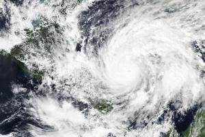
A category 4 hurricane, Eta is expected to make landfall in Nicaragua on 3 November. The National Hurricane Center and Central Pacific Hurriance Center of the National Oceanic and Atmospheric Administration (NOAA) of the United States of America is warning that it could became a category 5 hurricane before making landfall. According to NOAA, catastrophic wind damage is expected where Eta's eyewall moves onshore within the Hurricane Warning area (coast of Nicaragua from the Honduras/Nicaragua border to Sandy Bay Sirpi) in the morning of 3 November, with tropical storm conditions in the larger area beginning within the next couple of hours.
Upon the request of the Central American Coordination Center for Natural Disaster Prevention (
| Organization | Title | Product type | Link |
|---|---|---|---|
| European Commission, Copernicus Emergency Management Service (EMS) | EMSR477: Tropical Cyclone in North Caribbean Region, Nicaragua | Maps, vector data | URL |
| European Commission, Copernicus Emergency Management Service (EMS) | EMSR481: Tropical Cyclone Eta in Honduras | Maps, vector data | URL |
| NASA Disasters Program | NASA Products for Hurricane Eta 2020 | Maps, imagery, Web Map Services (WMS) | URL |
| Central American Coordination Center for Natural Disaster Prevention (CEPREDENAC) | CEPREDENAC Portal | Web GIS | URL |
| United Nations Office for the Coordination of Humanitarian Affairs (UNOCHA) | ReliefWeb - Map products, Hurricanes Eta and Iota | Repository of products (situational updates, maps, infographics) | URL |
| United Nations Institute for Training and Research (UNITAR) Operational Satellite Applications Programme (UNOSAT) | Latest maps | Maps, Web GIS | URL |
| National Oceanic and Atmospheric Administration (NOAA), National Hurricane Center and Central Pacific Hurricane Center | Hurricane Eta | Forecasts (wind speed probabilities, arrival time of winds, warnings/cone maps, key messages) | URL |
| European Commission, Copernicus Emergency Management Service (EMS) | Global Floods Awareness System (GloFAS) | Operational system monitoring and forecasting floods across the world (focuses on rivers, and does not provide real-time forecast information on flash flood risk or coastal flooding, nor on inundated areas.) | URL (requires free account) |
| HazMapper | Potential landslide mapping in Google Earth Engine | Web GIS | URL |
| MapAction | Hurricane Eta, November 2020 | Maps | URL |
