  • English
  • Español
  • Français

United
Nations


Office for Outer Space Affairs
UN-SPIDER Knowledge Portal

  • Inicio
  • Sobre nosotros
    • Sobre ONU-SPIDER
    • Acerca de UNOOSA
    • Publicaciones
    • Ofertas de trabajo
    • Conozca el Equipo
    • Contacto
  • Aplicación Espacial
    • Guías Tecnológicas
    • Mecanismos de Emergencia
    • Mecanismos de Recuperación
    • Red Internacional de Alerta de Asteroides
    • Grupo Asesor para la Planificación de Misiones Espaciales
    • Iniciativa Internacional sobre Meteorología Espacial
    • Tecnologías Espaciales en la ONU
    • Historias de Usuarios
  • Enlaces y Recursos
    • Aplicación de datos del mes
      • Disaster Recovery
    • Fuentes de Datos
    • SIG y Software de Percepción Remota
    • Recursos de capacitación en línea
    • Instituciones
  • Riesgos y Desastres
    • Gestión del Riesgo de Desastres
    • Alerta temprana
    • Gestión de Desastres y Emergencias
    • Amenazas Naturales
    • El Proceso de la Reducción de Desastres Post-2015
    • La ONU y la Gestión del Riesgo de Desastres
    • La ONU y Alerta Temprana
    • La ONU y la Gestión de Desastres
  • Asesoría
    • Misiones de Asesoría
    • Apoyo en caso de Emergencia
    • Asesoría Virtual
    • Prácticas Recomendadas
    • Actividades de Entrenamiento
    • Usos Prácticos
  • Redes
    • Oficinas Regionales de Apoyo
    • GP-STAR
    • IN-MHEWS
    • IWG-SEM
  • Proyectos
    • SPEAR
    • FOSAT-S
    • EvIDENz
    • Flood GUIDE
    • CommonSpace Initiative
    • Tonga Pilot Project
  • Noticias y Eventos
    • Noticias
    • Eventos
    • Eventos pasados

Breadcrumb

  • Home
  • New Recommended Practice: Agriculture Drought Monitoring And Hazard Assessment Using Google Earth Engine
  • New Recommended Practice: Agriculture Drought Monitoring and Hazard Assessment using Google Earth Engine

New Recommended Practice: Agriculture Drought Monitoring and Hazard Assessment using Google Earth Engine

VHI Result Example

UN-SPIDER's Regional Support Office of Pakistan (SUPARCO) has provided a new Recommended Practice, using Google Earth Engine to identify the drought extent and severity by calculating different indices.

Drought is a slow on-set disaster which affects agriculture and associated livelihood in many parts of the world. It causes stress to vegetation; hence the extent of a drought can be reflected by changes in the vegetation condition. Geospatial scientists have developed drought indices based on remote sensing data to effectively detect drought conditions.

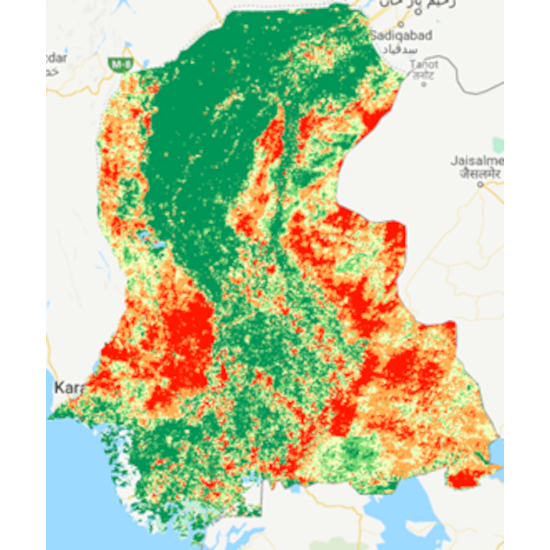
Droughts make considerable effects on agricultural and agro-pastoral areas due to their substantial dependency on rainfall. Agricultural drought monitoring is very important to maintain food security in the world. Satellite remote sensing is widely used for vegetation health monitoring and has become a powerful drought detection approach, because of its use at the global level. Indices have been developed using remote sensing data like the Normalized Difference Vegetation Index (NDVI), Land Surface Temperature (LST), Vegetation Condition Index (VCI), and Vegetation Health Index (VHI). These are employed to onset and monitor the agriculture drought in the relation to the plant growth.

The recommended practice is prepared to monitor and perform early warning of agriculture drought and can be easily adapted using Google Earth Engine.

Find further information, details, and a step-by-step explanation on the page of the Recommended Practice.

https://un-spider.org/advisory-support/recommended-practices/recommended-practi…
Fri, 20 May 2022 - 16:47
Drought
Space and Upper Atmosphere Research Commission (SUPARCO)

Footer menu

  • Contact
  • Terms of Use

User account menu

  • Log in