  • English
  • Español
  • Français

United
Nations


Office for Outer Space Affairs
UN-SPIDER Knowledge Portal

  • Inicio
  • Sobre nosotros
    • Sobre ONU-SPIDER
    • Acerca de UNOOSA
    • Publicaciones
    • Ofertas de trabajo
    • Conozca el Equipo
    • Contacto
  • Aplicación Espacial
    • Guías Tecnológicas
    • Mecanismos de Emergencia
    • Mecanismos de Recuperación
    • Red Internacional de Alerta de Asteroides
    • Grupo Asesor para la Planificación de Misiones Espaciales
    • Iniciativa Internacional sobre Meteorología Espacial
    • Tecnologías Espaciales en la ONU
    • Historias de Usuarios
  • Enlaces y Recursos
    • Aplicación de datos del mes
      • Disaster Recovery
    • Fuentes de Datos
    • SIG y Software de Percepción Remota
    • Recursos de capacitación en línea
    • Instituciones
  • Riesgos y Desastres
    • Gestión del Riesgo de Desastres
    • Alerta temprana
    • Gestión de Desastres y Emergencias
    • Amenazas Naturales
    • El Proceso de la Reducción de Desastres Post-2015
    • La ONU y la Gestión del Riesgo de Desastres
    • La ONU y Alerta Temprana
    • La ONU y la Gestión de Desastres
  • Asesoría
    • Misiones de Asesoría
    • Apoyo en caso de Emergencia
    • Asesoría Virtual
    • Prácticas Recomendadas
    • Actividades de Entrenamiento
    • Usos Prácticos
  • Redes
    • Oficinas Regionales de Apoyo
    • GP-STAR
    • IN-MHEWS
    • IWG-SEM
  • Proyectos
    • SPEAR
    • FOSAT-S
    • EvIDENz
    • Flood GUIDE
  • Noticias y Eventos
    • Noticias
    • Eventos
    • Eventos pasados
  • Admin
    • SAM Items

Breadcrumb

  • Home
  • ALOS-4 / DAICHI-4
  • ALOS-4 / DAICHI-4

ALOS-4 / DAICHI-4

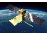
The Advanced Land Observing Satellite-4 (ALOS-4) is a satellite to observe the Earth's surface using its onboard phased array type L-band synthetic aperture radar (PALSAR-3). The L-band radar technology has continuously been developed in Japan. With further improved observation performance compared to the predecessor PALSAR-2 aboard the DAICHI-2 (ALOS-2), JAXA and its prime contractor, Mitsubishi Electric Corporation, are developing the satellite aiming at achieving both high resolution and a broader observation swath.
Unlike observations by an optical sensor, radar images can be acquired day and night as it does not require sunlight. Moreover, since radio waves can penetrate cloud, the images can be obtained regardless of weather condition. The ALOS-4 will leverage these merits for observing and monitoring disaster-hit areas, forests, and sea ice. In addition, it will also challenge new areas such as monitoring infrastructure displacement.
The ALOS-4 will be equipped with the Automatic Identification System for ships (AIS) receiver, as was DAICHI-2, so that the satellite will also monitor oceans by receiving AIS signals from vessels as well as by acquiring the PALSAR-3 images. The SPace based AIS Experiment (SPAISE3) is a high performance satellite AIS. Effective countermeasures against radio wave interference regions are taken for the SPAISE3 with multiple antennas and groundbased data processing; therefore, the detection success rate of a ship in the heavy marine traffic areas will be improved compared to DAICHI-2. SPAISE3 development is JAXA's ongoing project in cooperation with NEC Corporation.

1 Jul 2024
7years
Sun synchronous
L-band synthetic aperture (PALSAR)
JAXA
Monitoring land deformation and subsidence, disaster prevention, forest management, monitoring infrastructure displacement
Desborde de lago glaciar
Incendio
Tsunami
Terremoto
Erupción volcánica
Subsidencia
Desplazamiento de masas
Deslizamiento de tierra
Inundación
L-Band active Radar
No
https://global.jaxa.jp/projects/sat/alos4/index.html

Footer menu

  • Contact
  • Terms of Use

User account menu

  • Log in