![]()
United
Nations
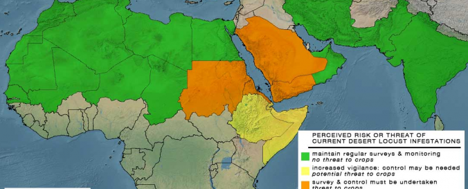
Locust Watch (DLIS - FAO)
| Data provided by: | Food and Agriculture Organization of the United Nations (FAO) |
| Data accessibility: | Exportar mapa |
| Link to the data: | |
| Data type: | Datos sobre amenazas específicas |
| Hazard: | Insect Infestation |
| Disaster cycle phase: | Gestión des Riesgo por Desastres, Respuesta, Recuperación |
| Satellites and Sensors: | Aqua, Terra, NOAA-15, SPOT 4, Meteosat-8 (SEVIRI) |
| Spatial coverage: | Algeria, Chad, Eritrea, India, Mauritania, Pakistan, Saudi Arabia, Sudan, Yemen |
| Spatial resolution: | 250.00 |
| Temporal coverage: | Archivado, Casi en tiempo real |
| Content dates: | 2000-present |
| Technical Specifications: | |
| Costs: | Gratis |
| Tutorials on the use of data: | Technical Note for Desert Locust product |
| Restrictions/ Citation of the dataset: |
Provider
![]()