• English
  • Español
  • Français

United
Nations


Office for Outer Space Affairs
UN-SPIDER Knowledge Portal

  • Inicio
  • Sobre nosotros
    • Sobre ONU-SPIDER
    • Acerca de UNOOSA
    • Publicaciones
    • Ofertas de trabajo
    • Conozca el Equipo
    • Contacto
  • Aplicación Espacial
    • Guías Tecnológicas
    • Mecanismos de Emergencia
    • Mecanismos de Recuperación
    • Red Internacional de Alerta de Asteroides
    • Grupo Asesor para la Planificación de Misiones Espaciales
    • Iniciativa Internacional sobre Meteorología Espacial
    • Tecnologías Espaciales en la ONU
    • Historias de Usuarios
  • Enlaces y Recursos
    • Aplicación de datos del mes
      • Disaster Recovery
    • Fuentes de Datos
    • SIG y Software de Percepción Remota
    • Recursos de capacitación en línea
    • Instituciones
  • Riesgos y Desastres
    • Gestión del Riesgo de Desastres
    • Alerta temprana
    • Gestión de Desastres y Emergencias
    • Amenazas Naturales
    • El Proceso de la Reducción de Desastres Post-2015
    • La ONU y la Gestión del Riesgo de Desastres
    • La ONU y Alerta Temprana
    • La ONU y la Gestión de Desastres
  • Asesoría
    • Misiones de Asesoría
    • Apoyo en caso de Emergencia
    • Asesoría Virtual
    • Prácticas Recomendadas
    • Actividades de Entrenamiento
    • Usos Prácticos
  • Redes
    • Oficinas Regionales de Apoyo
    • GP-STAR
    • IN-MHEWS
    • IWG-SEM
  • Proyectos
    • SPEAR
    • FOSAT-S
    • EvIDENz
    • Flood GUIDE
  • Noticias y Eventos
    • Noticias
    • Eventos
    • Eventos pasados

Breadcrumb

  • Home
  • EU Copernicus Mapping Services Produces Maps For Floods In Balkan States
  • EU Copernicus Mapping Services produces maps for floods in Balkan states

EU Copernicus Mapping Services produces maps for floods in Balkan states

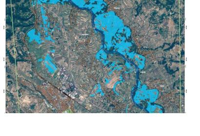
Extent of floods near Jagodina, Serbia on 15 May 2014Extent of floods near Jagodina, Serbia on 15 May 2014

The Emergency Mapping Service of the European Union's Copernicus programme was activated to provide satellite-based maps of the severe floods in Croatia, Bosnia and Herzegovina, and Serbia.

The service produced four maps for Croatia, 18 maps for Bosnia and Herzegovina, and 20 maps of Serbia.

NASA's Earth Observatory has also published a satellite image of the floods in Croatia, Serbia, and Bosnia and Herzegovina on May 19, 2014. By comparing the current image to an image from 18 May 2013, the massive extent of the floods becomes clearly visible.

Due to heavy rains and widespread flooding, the Serbia declared a State of Emergency for the whole territory of the Republic. The most seriously affected regions are Kolubara, Mačva and Morava. Critical infrastructure systems are severely affected in several parts of the country, including railway traffic between Belgrade and Nis. In Croatia, severe flooding and unexpectedly fast rising of the water level occured in Slavonija region in east Croatia, near the Bosnian border.


Following the international response to the flood events in the Balkans, UN-SPIDER compiled a list of available satellite imagery and maps of the flooded areas. 
Emergency Mapping Service Copernicus
Tue, 20 May 2014 - 16:09
Serbia
Croatia
Bosnia and Herzegovina

Footer menu

  • Contact
  • Terms of Use

User account menu

  • Log in